IMAGES TAKEN NEAR TO
Rosswood Gardens, WALLINGTON, SM6 8QZ
Introduction
This page details the photographs taken nearby to Rosswood Gardens, SM6 8QZ by members of the Geograph project.
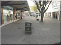
The Geograph project started in 2005 with the aim of publishing, organising and preserving representative images for every square kilometre of Great Britain, Ireland and the Isle of Man.

There are currently over 7.5m images from over14,400 individuals and you can help contribute to the project by visiting https://www.geograph.org.uk
Image Map
Images are licensed for reuse under creativecommons.org/licenses/by-sa/2.0
Notes
- Clicking on the map will re-center to the selected point.
- The higher the marker number, the further away the image location is from the centre of the postcode.
Image Listing (115 Images Found)
Images are licensed for reuse under creativecommons.org/licenses/by-sa/2.0
Image
Details
Distance
1
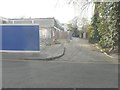
Derelict buildings awaiting demolition
These stand off Clarendon Road, Wallington and the redevelopment of the site is described in Sutton Council’s planning application D2013/67339 as the “demolition of numbers 3-21 Wallington Square and 26 Clarendon Road; erection of a phased development of two A1 retail units A1/A3 units, erection of eighteen 1-bedroomed, six 2-bedroomed and six 3-bedroomed self-contained flats in two 3 storey blocks above the redevelopment units, provision of 20 parking spaces with the reorganised service road to include loading bays. 36 cycle parking spaces and refuse storage and provision of canopy structure to cover existing shopping mall”.
Image: © John Baker
Taken: 18 Nov 2014
0.01 miles
2
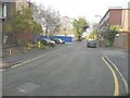
Looking NNW along Clarendon Road, Wallington
Foundation House stands on the right, while the blue hoarding further up the road hides a site described in Sutton Council’s planning application D2013/67339 as the “demolition of numbers 3-21 Wallington Square and 26 Clarendon Road; erection of a phased development of two A1 retail units A1/A3 units, erection of eighteen 1-bedroomed, six 2-bedroomed and six 3-bedroomed self-contained flats in two 3 storey blocks above the redevelopment units, provision of 20 parking spaces with the reorganised service road to include loading bays. 36 cycle parking spaces and refuse storage and provision of canopy structure to cover existing shopping mall”.
Image: © John Baker
Taken: 18 Nov 2014
0.02 miles
3

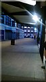
Back of shops, Woodcote Centre, Wallington
The back of Image]
Image: © Rich Tea
Taken: 17 Jun 2008
0.02 miles
4
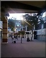
Precinct, Wallington, sunset
A small pedestrian precinct off Woodcote Road gives access to a back entrance to Sainsbury's (off the right of the picture).
Taken at sunset, as the streetlights came on.
Image: © Christopher Hilton
Taken: 4 Oct 2013
0.03 miles
5

Shops in the Woodcote Centre, Wallington
Seen from Clarendon Road
Image: © Rich Tea
Taken: 17 Jun 2008
0.03 miles
6
Precinct, Wallington, sunset
A small pedestrian precinct off Woodcote Road gives access to a back entrance to Sainsbury's (off the left of the picture).
Taken at sunset, as the streetlights came on.
Image: © Christopher Hilton
Taken: 4 Oct 2013
0.03 miles
7
Wallington Square shopping precinct
Access to this shopping precinct can be made from Clarendon Road or Woodcote Road.
Image: © John Baker
Taken: 18 Nov 2014
0.04 miles
8
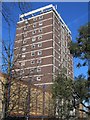
Rosemount Towers, Wallington
A residential tower block above the Sainsbury supermarket
Image: © Richard Rogerson
Taken: 5 Mar 2014
0.05 miles
9
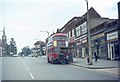
RT bus in Wallington
RT 3268 on route 157 is the subject, but the background is also of interest. The shops have changed hands and Woolworths has closed. Of particular note is the spire of Christ Church Presbyterian Church, which was subsequently demolished and is now a Sainsbury's superstore. A real snapshot in time.
Image: © JOHN PARKIN
Taken: 24 Sep 1972
0.06 miles
