IMAGES TAKEN NEAR TO
Curran Avenue, WALLINGTON, SM6 7JN
Introduction
This page details the photographs taken nearby to Curran Avenue, SM6 7JN by members of the Geograph project.
The Geograph project started in 2005 with the aim of publishing, organising and preserving representative images for every square kilometre of Great Britain, Ireland and the Isle of Man.

There are currently over 7.5m images from over14,400 individuals and you can help contribute to the project by visiting https://www.geograph.org.uk
Image Map
Images are licensed for reuse under creativecommons.org/licenses/by-sa/2.0
Notes
- Clicking on the map will re-center to the selected point.
- The higher the marker number, the further away the image location is from the centre of the postcode.
Image Listing (111 Images Found)
Images are licensed for reuse under creativecommons.org/licenses/by-sa/2.0
Image
Details
Distance
1
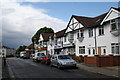
Shopping parade, Butter Hill, Carshalton, Surrey
Like many small shopping areas, this one is in decline with the loss of many shops, either boarded up or converted into residential accommodation.
Image: © Dr Neil Clifton
Taken: 4 Jul 2007
0.12 miles
2
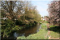
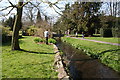
Carshalton: River Wandle
West of London Road, the River Wandle emerges from its culvert, but it is not possible to walk along the banks here, as thy form part of the private gardens of houses in Riverside Close (left) and Bowmans Meadow (right).
Image: © Dr Neil Clifton
Taken: 9 Apr 2010
0.13 miles
4
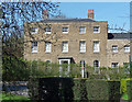
282 London Road
Plain but stately late C18th house with arched ground-floor windows. Grade II listed.
Currently Bridge House, a care home for elderly people.
Image: © Stephen Richards
Taken: 12 Apr 2015
0.13 miles
5
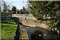
Carshalton: River Wandle
The River Wandle is seen here on the north side of the Grange Park lake, having collected most of the outflow water.
Image: © Dr Neil Clifton
Taken: 9 Apr 2010
0.16 miles
6
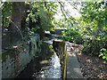
Carshalton: River Wandle
Flowing west, the River Wandle reaches London Road, where it disappears under the road into a low culvert-like bridge. The road is part of the A237.
Image: © Dr Neil Clifton
Taken: 9 Apr 2010
0.17 miles
7
Confluence on the Wandle
The flow of the river through and around the lake in Beddington Park is complex; here the outflow from the lake (foreground) rejoins the main stream.
Image: © Stephen Craven
Taken: 19 Aug 2012
0.17 miles
9
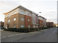
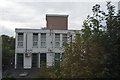
Apartment block in Carshalton
A modern apartment block on Butter Hill, in Carshalton.
Image: © Malc McDonald
Taken: 4 Jan 2020
0.17 miles
10
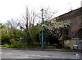
Carshalton: Mill Lane
This shows the ornamental sewer vent pipe next to Three Arch Bridge, which is the correct name of the railway bridge over Mill Lane. This sewer vent pipe seems to be intact, but is badly corroded and in need of a repaint.
Image: © Dr Neil Clifton
Taken: 14 Apr 2012
0.17 miles