IMAGES TAKEN NEAR TO
Twill Way, WALLINGTON, SM6 7EZ
Introduction
This page details the photographs taken nearby to Twill Way, SM6 7EZ by members of the Geograph project.
The Geograph project started in 2005 with the aim of publishing, organising and preserving representative images for every square kilometre of Great Britain, Ireland and the Isle of Man.

There are currently over 7.5m images from over14,400 individuals and you can help contribute to the project by visiting https://www.geograph.org.uk
Image Map
Images are licensed for reuse under creativecommons.org/licenses/by-sa/2.0
Notes
- Clicking on the map will re-center to the selected point.
- The higher the marker number, the further away the image location is from the centre of the postcode.
Image Listing (84 Images Found)
Images are licensed for reuse under creativecommons.org/licenses/by-sa/2.0
Image
Details
Distance
1
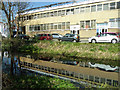
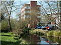
Wandle reflections, Hackbridge
Units at Sutton Business Park are partly reflected in the River Wandle.
Image: © Robin Webster
Taken: 28 Mar 2012
0.03 miles
2
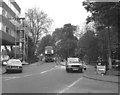
The Hack Bridge on the B277
The bridge seen here under repair is on a very old route from Carshalton to London. Known as the Hack Bridge, it crosses the River Wandle, and it has given its name to a whole suburban area, including a station.
A Routemaster bus on Route 77 is seen crossing the bridge.
Image: © Dr Neil Clifton
Taken: 21 Apr 1981
0.05 miles
4
Offices by River Wandle
Called Navigator House.
Image: © Robin Webster
Taken: 28 Mar 2012
0.06 miles
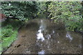
7

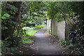
Hackbridge Road (B277)
Looking north of Hack Bridge over the River Wandle.
Image: © Robin Webster
Taken: 28 Mar 2012
0.06 miles
8
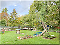
Hackbridge Community Garden
Garden off Nightingale Road alongside the River Wandle by the Hack Bridge (in the background) created in 2016-8 by local artist Claudio Funari from what was previously an overgrown patch of ground.
Image: © Ian Capper
Taken: 7 Oct 2022
0.07 miles
9
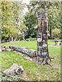
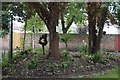
Hackbridge Community Garden
Garden off Nightingale Road alongside the River Wandle by the Hack Bridge created in 2016-8 by local artist Claudio Funari from what was previously an overgrown patch of ground.
Image: © Ian Capper
Taken: 7 Oct 2022
0.07 miles