IMAGES TAKEN NEAR TO
Heathdene Road, WALLINGTON, SM6 0TB
Introduction
This page details the photographs taken nearby to Heathdene Road, SM6 0TB by members of the Geograph project.
The Geograph project started in 2005 with the aim of publishing, organising and preserving representative images for every square kilometre of Great Britain, Ireland and the Isle of Man.

There are currently over 7.5m images from over14,400 individuals and you can help contribute to the project by visiting https://www.geograph.org.uk
Image Map
Images are licensed for reuse under creativecommons.org/licenses/by-sa/2.0
Notes
- Clicking on the map will re-center to the selected point.
- The higher the marker number, the further away the image location is from the centre of the postcode.
Image Listing (22 Images Found)
Images are licensed for reuse under creativecommons.org/licenses/by-sa/2.0
Image
Details
Distance
1
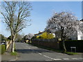
Street Scene, Heathdene Road, Carshalton
Cherry blossom on the tree shows that Spring is almost here.
Image: © Peter Trimming
Taken: 17 Mar 2009
0.05 miles
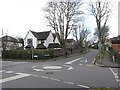
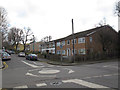
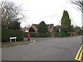
2
Park Hill Road, Wallington
Looking downhill from the junction with Heathdene Road, with a postbox on the corner.
Image: © Stephen Craven
Taken: 6 Feb 2015
0.09 miles
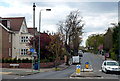
3
Brambledown Road, Wallington, looking west
From the junction of Park Hill Road with a mini roundabout in the foreground.
Image: © Stephen Craven
Taken: 6 Feb 2015
0.10 miles
4
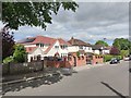
Park Hill Road
Newly updated detached property has substantial additions.
Image: © James Emmans
Taken: 11 May 2020
0.15 miles
5
Brambledown Road, Wallington, looking east
From the junction of Park Hill Road with a mini roundabout in the foreground.
Image: © Stephen Craven
Taken: 6 Feb 2015
0.15 miles
6
Carshalton: Stanley Park Road
Looking west at the junction with Boundary Road. One of the sewer vent pipes is seen, but this one has been mutilated, losing both its crown and its arrow, leaving only the vent globe.
Image: © Dr Neil Clifton
Taken: 16 Apr 2012
0.15 miles
7
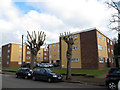
Burns Court, Park Hill Road, Wallington
The development consists of three blocks of flats.
Image: © Stephen Craven
Taken: 6 Feb 2015
0.16 miles
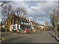
8
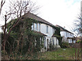
Abandoned house, Stanley Park Road, Wallington
Boarded up and overgrown with creepers, this house looks to have been uninhabited for a long time.
Image: © Stephen Craven
Taken: 6 Feb 2015
0.16 miles
9
Park Hill Road, Wallington
Looking downhill from the junction with Woodcote Avenue, with a postbox on the corner.
Image: © Stephen Craven
Taken: 6 Feb 2015
0.17 miles
10
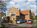
Wallington United Reformed Church, Stanley Park Road
Originally Holmwood Gardens Congregational Church, founded 1907. Certainly the Arts-and-Crafts style of architecture suggests that period. There is an adjacent hall Image
Image: © Stephen Craven
Taken: 6 Feb 2015
0.18 miles