IMAGES TAKEN NEAR TO
Stanley Park Road, WALLINGTON, SM6 0EU
Introduction
This page details the photographs taken nearby to Stanley Park Road, SM6 0EU by members of the Geograph project.
The Geograph project started in 2005 with the aim of publishing, organising and preserving representative images for every square kilometre of Great Britain, Ireland and the Isle of Man.

There are currently over 7.5m images from over14,400 individuals and you can help contribute to the project by visiting https://www.geograph.org.uk
Image Map (Loading...)


Getting Data...Please wait
Leaflet Map data © OpenStreetMap
Images are licensed for reuse under creativecommons.org/licenses/by-sa/2.0
Notes
- Clicking on the map will re-center to the selected point.
- The higher the marker number, the further away the image location is from the centre of the postcode.
Image Listing (94 Images Found)
Images are licensed for reuse under creativecommons.org/licenses/by-sa/2.0
Image
Details
Distance
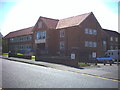
1
Cloverdale Court, Wallington
Sheltered housing and day care centre.
Image: © Stephen Craven
Taken: 6 Feb 2015
0.00 miles
2
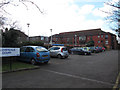
Shotfield car parks, Wallington (2)
There are public car parks either side of the road. See also Image
Image: © Stephen Craven
Taken: 6 Feb 2015
0.03 miles
3
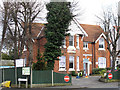
Gaytime Nursery, Stanley Park Road, Wallington
A large suburban house now in use as a children's nursery.
Image: © Stephen Craven
Taken: 6 Feb 2015
0.04 miles
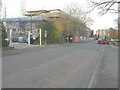
4
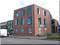
Jubilee Health Centre, Wallington
The centre opened in 2012 and is at the corner of Shotfields and Stanley Park Road. The white van was delivering supplies to the pharmacy.
Image: © Stephen Craven
Taken: 6 Feb 2015
0.04 miles
5
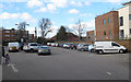
Sutton Magistrates' Court, Shotfield, Wallington.
Image: © Noel Foster
Taken: 31 Aug 2005
0.05 miles
6
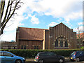
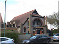
Wallington United Reformed Church, Stanley Park Road
Originally Holmwood Gardens Congregational Church, founded 1907. Certainly the Arts-and-Crafts style of architecture suggests that period. This is the east side; see also Image There is an adjacent hall Image
Image: © Stephen Craven
Taken: 6 Feb 2015
0.06 miles
7
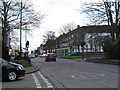
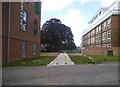
Stanley Park Road, Wallington
The road forms part of the B271 from Carshalton to Croydon.
Image: © Stephen Craven
Taken: 6 Feb 2015
0.06 miles
8
Erection of assisted care living accommodation, Shotfield
The redevelopment of the former Wallington magistrates court is described in Sutton Council’s planning application D2012/66638 as the “erection of part three, part five storey building to provide forty two-bedroomed and fifteen 2-bedroomed assisted living care accommodation and community facilities (Class D1) together with integral refuse, recycling, mobility buggies and cycle area and provision of car parking. new access road and associated landscaping”. The developer is McCarthy and Stone. Thanks for Noel Foster for photographing Image before they disappeared for good.
Image: © John Baker
Taken: 18 Nov 2014
0.06 miles
9
Flats on Stanley Park Road, Wallington
The Jubilee Health Centre is on the left
Image: © David Howard
Taken: 20 Sep 2015
0.06 miles
10
Holmwood Hall, Wallington
The hall looks contemporary with the adjacent church Image and so probably built around the same time (1907), certainly the Arts-and-Crafts style of architecture suggests that period.
Image: © Stephen Craven
Taken: 6 Feb 2015
0.06 miles