IMAGES TAKEN NEAR TO
Bankside Close, CARSHALTON, SM5 3SB
Introduction
This page details the photographs taken nearby to Bankside Close, SM5 3SB by members of the Geograph project.
The Geograph project started in 2005 with the aim of publishing, organising and preserving representative images for every square kilometre of Great Britain, Ireland and the Isle of Man.

There are currently over 7.5m images from over14,400 individuals and you can help contribute to the project by visiting https://www.geograph.org.uk
Image Map
Images are licensed for reuse under creativecommons.org/licenses/by-sa/2.0
Notes
- Clicking on the map will re-center to the selected point.
- The higher the marker number, the further away the image location is from the centre of the postcode.
Image Listing (60 Images Found)
Images are licensed for reuse under creativecommons.org/licenses/by-sa/2.0
Image
Details
Distance
1
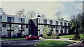
Bankside Close, Carshalton
Photograph taken in the 1960s with red Sunbeam Alpine
Image: © Cynthia Barber
Taken: Unknown
0.02 miles
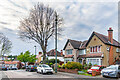
2
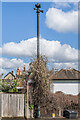
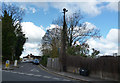
Sewer vent column, Banstead Road/Park Hill
Sewer vent column at the junction of Banstead Road and Park Hill, one of at least 31 such columns in Carshalton (see description below - this is no 1 on the map). This example has the arrow below the globe at the top of the column and no crown. Grade II listed - see https://historicengland.org.uk/listing/the-list/list-entry/1467952?section=official-list-entry. For a wider view see Image
Image: © Ian Capper
Taken: 25 Apr 2023
0.04 miles
3
Carshalton: Banstead Road
Looking into the south end of Banstead Road, we see an ornamental sewer vent pipe, which sadly has been mutilated by the removal of the crown which was originally at the top.
Image: © Dr Neil Clifton
Taken: 15 Apr 2012
0.04 miles
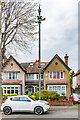
4
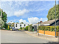
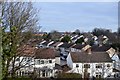
Bankside Close
1970s cul de sac off Park Hill.
Image: © Ian Capper
Taken: 7 Oct 2022
0.04 miles
5
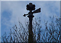
Carshalton: Mutilated sewer vent
This shows the top of the vent pipe Image which has had the crown cut off from the top. Shame on you, Sutton LBC, for not looking after your heritage!
Image: © Dr Neil Clifton
Taken: 15 Apr 2012
0.05 miles
6
Carshalton: Wales Avenue
Looking west, with one of the ornamental sewer vent pipes.
Image: © Dr Neil Clifton
Taken: 15 Apr 2012
0.10 miles
7
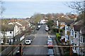
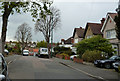
Wales Avenue
Looking along Wales Avenue, a road first marked on the 1896 25 inch map as a cul-de-sac with limited development and more fully developed on the 1913 edition but still a cul-de-sac, ending at nos 20 & 22, the houses on the right in this photo. A full extension westwards through to Harrow Road is shown on the 1935 edition. In the centre of the photo is the sewer vent column in Image
Image: © Ian Capper
Taken: 26 Apr 2023
0.10 miles
8
Sewer vent column, Wales Avenue
Sewer vent column in Wales Avenue, one of at least 31 such columns in the old Carshalton UDC area (see description below, although this one is not shown on the map). This example has the arrow below the globe at the top of the column. Grade II listed - see https://historicengland.org.uk/listing/the-list/list-entry/1469057?section=official-list-entry. For a wider view see Image
Image: © Ian Capper
Taken: 26 Apr 2023
0.10 miles