IMAGES TAKEN NEAR TO
Stanley Park Road, CARSHALTON, SM5 3JW
Introduction
This page details the photographs taken nearby to Stanley Park Road, SM5 3JW by members of the Geograph project.
The Geograph project started in 2005 with the aim of publishing, organising and preserving representative images for every square kilometre of Great Britain, Ireland and the Isle of Man.

There are currently over 7.5m images from over14,400 individuals and you can help contribute to the project by visiting https://www.geograph.org.uk
Image Map
Images are licensed for reuse under creativecommons.org/licenses/by-sa/2.0
Notes
- Clicking on the map will re-center to the selected point.
- The higher the marker number, the further away the image location is from the centre of the postcode.
Image Listing (49 Images Found)
Images are licensed for reuse under creativecommons.org/licenses/by-sa/2.0
Image
Details
Distance
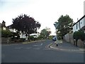
1
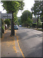
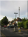
Stanley Park Road dropping westwards into the valley
The B278 (Beeches Avenue / Woodmansterne Road) follows a valley southwards out of Carshalton: Stanley Park Road here forms part of an east-west route that dips into that valley and up out on the other side.
Image: © Christopher Hilton
Taken: 4 Jul 2014
0.02 miles
2
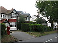
The Beeches Avenue (2)
Shows the location of Image
Image: © Mike Quinn
Taken: 23 Jul 2008
0.05 miles
3
Carshalton: Queen Mary's Avenue
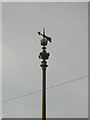
Looking north at the crossroads with Stanley Park Road. Another fine ornamental sewer vent pipe, in good condition with the arrow uppermost.
Image: © Dr Neil Clifton
Taken: 16 Apr 2012
0.05 miles
4

Penfold postbox, The Beeches Avenue - royal cipher and crest
See Image
Image: © Mike Quinn
Taken: 23 Jul 2008
0.05 miles
5
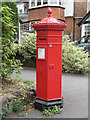
Penfold postbox, The Beeches Avenue
Image: © Mike Quinn
Taken: 23 Jul 2008
0.06 miles
6
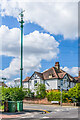
Sewer vent column, Queen Mary's Avenue
Sewer vent column at the junction of Queen Mary's Avenue and Stanley Park Road, one of at least 31 such columns in Carshalton (see description below - this is no 19 on the map). This example has the arrow above the crown at the top of the column. Grade II listed - see https://historicengland.org.uk/listing/the-list/list-entry/1469016?section=official-list-entry.
Image: © Ian Capper
Taken: 25 Apr 2023
0.06 miles
7
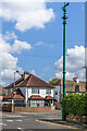
Stinkpipe, junction of Fountain Drive and Stanley Park Road, Carshalton: detail
This ornate stinkpipe design is common along the southern edges of what is now the London Borough of Sutton.
Image: © Christopher Hilton
Taken: 4 Jul 2014
0.06 miles
8
Stinkpipe, junction of Fountain Drive and Stanley Park Road, Carshalton
This ornate stinkpipe design is common along the southern edges of what is now the London Borough of Sutton.
Below it, a pizza delivery motorcycle goes about its Friday-evening business.
Image: © Christopher Hilton
Taken: 4 Jul 2014
0.06 miles
9
Sewer vent column, Queen Mary's Avenue
Sewer vent column at the junction of Queen Mary's Avenue and Stanley Park Road, one of at least 31 such columns in Carshalton (see description below - this is no 19 on the map). This example has the arrow above the crown at the top of the column. Grade II listed - see https://historicengland.org.uk/listing/the-list/list-entry/1469016?section=official-list-entry.
Image: © Ian Capper
Taken: 25 Apr 2023
0.06 miles
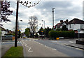
10
Kings Avenue at the junction of Diamond Jubilee Way
Image: © David Howard
Taken: 30 Jun 2018
0.06 miles