IMAGES TAKEN NEAR TO
Beddington Gardens, CARSHALTON, SM5 3HQ
Introduction
This page details the photographs taken nearby to Beddington Gardens, SM5 3HQ by members of the Geograph project.
The Geograph project started in 2005 with the aim of publishing, organising and preserving representative images for every square kilometre of Great Britain, Ireland and the Isle of Man.

There are currently over 7.5m images from over14,400 individuals and you can help contribute to the project by visiting https://www.geograph.org.uk
Image Map
Images are licensed for reuse under creativecommons.org/licenses/by-sa/2.0
Notes
- Clicking on the map will re-center to the selected point.
- The higher the marker number, the further away the image location is from the centre of the postcode.
Image Listing (22 Images Found)
Images are licensed for reuse under creativecommons.org/licenses/by-sa/2.0
Image
Details
Distance
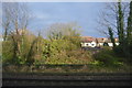
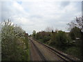
2
Carshalton: Park Lane
Looking north from the railway bridge. The ornamental sewer vent pipe here seems to be on good condition. It is one of the less-usual type with the arrow uppermost,and the crown below it.
Image: © Dr Neil Clifton
Taken: 16 Apr 2012
0.11 miles
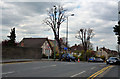
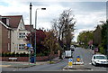
3

DMS 1608 Bus Route 154
London Transport DMS bus 1608 crosses the railway line west of Wallington Station and passes from Park Lane into Boundary Road. This road was served by trams 1906-1935; trolleybuses 1935-1959; RT buses 1959-1973 and DMS buses 1973-1977, when the route was diverted through Carshalton Beeches and along the full length of Stanley Park Road. Note the sewer ventilation pole, I believe also known as stink poles.
Image: © JOHN PARKIN
Taken: Unknown
0.13 miles
5
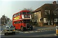
RT bus on route 154 at Boundary Corner
Photographed in 1973 shortly before these open platform buses with a conductor were replaced with one man buses, we see RT 4173 on route 154 about to turn from Boundary Road into Stanley Park Road in Wallington. The route was later diverted and now runs from left to right of the photo. In earlier days both trams and trolleybuses had turned at this very spot.
Image: © JOHN PARKIN
Taken: 24 Mar 1973
0.16 miles
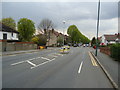
7
Carshalton: Stanley Park Road
Looking west at the junction with Boundary Road. One of the sewer vent pipes is seen, but this one has been mutilated, losing both its crown and its arrow, leaving only the vent globe.
Image: © Dr Neil Clifton
Taken: 16 Apr 2012
0.18 miles
8
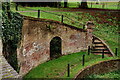
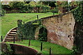
Carshalton Park
The park today occupies an area of 9.28 hectares, which is about one tenth of its original size.
The Grotto is situated in the south-east corner of the park. It was built in about 1724 as one of the first features of the ambitious designs for building and landscaping in the park.
A branch of the River Wandle used to rise in a subterranean chalk chamber beneath the Grotto. Within the recent past, water has again been seen at this location.
Image: © Peter Trimming
Taken: 2 Oct 2024
0.21 miles
9
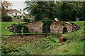
Carshalton Park
The park today occupies an area of 9.28 hectares, which is about one tenth of its original size.
The Grotto is situated in the south-east corner of the park. It was built in about 1724 as one of the first features of the ambitious designs for building and landscaping in the park.
A branch of the River Wandle used to rise in a subterranean chalk chamber beneath the Grotto. Within the recent past, water has again been seen at this location.
Image: © Peter Trimming
Taken: 2 Oct 2024
0.21 miles
10
Carshalton Park
The park today occupies an area of 9.28 hectares, which is about one tenth of its original size.
The Grotto is situated in the south-east corner of the park. It was built in about 1724 as one of the first features of the ambitious designs for building and landscaping in the park.
A branch of the River Wandle used to rise in a subterranean chalk chamber beneath the Grotto. Within the recent past, water has again been seen at this location.
Image: © Peter Trimming
Taken: 2 Oct 2024
0.21 miles