IMAGES TAKEN NEAR TO
Fellowes Road, CARSHALTON, SM5 2TD
Introduction
This page details the photographs taken nearby to Fellowes Road, SM5 2TD by members of the Geograph project.
The Geograph project started in 2005 with the aim of publishing, organising and preserving representative images for every square kilometre of Great Britain, Ireland and the Isle of Man.

There are currently over 7.5m images from over14,400 individuals and you can help contribute to the project by visiting https://www.geograph.org.uk
Image Map
Images are licensed for reuse under creativecommons.org/licenses/by-sa/2.0
Notes
- Clicking on the map will re-center to the selected point.
- The higher the marker number, the further away the image location is from the centre of the postcode.
Image Listing (38 Images Found)
Images are licensed for reuse under creativecommons.org/licenses/by-sa/2.0
Image
Details
Distance
1
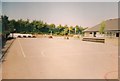
Rushy Meadow KS2 Playground
The Juniors' (Key Stage Two) Playground of Rushy Meadow Primary School in 2006.
Image: © PhotoMan9000
Taken: 25 Jul 2006
0.06 miles
2
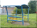
Metal bench
A covered blue and yellow bench on Rushy Meadow Field.
Image: © PhotoMan9000
Taken: 1 Sep 2012
0.11 miles
3
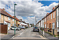
St Andrews Road
Road of mainly 19th Century terraced housing on the south side, but mainly c.1930s on the north side. The road was first marked on the 1896 25 inch map. In the middle of the photo, is the sewer vent column in Image
Image: © Ian Capper
Taken: 25 Apr 2023
0.12 miles
4
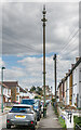
Sewer vent column, St Andrews Road
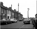
Sewer vent column in St Andrews Road, one of at least 31 such columns in the old Carshalton UDC area (see description below - this is no 21 on the map). This example has the arrow below the globe at the top of the column. Grade II listed - see https://historicengland.org.uk/listing/the-list/list-entry/1469869?section=official-list-entry. For a wider view see Image
Image: © Ian Capper
Taken: 25 Apr 2023
0.12 miles
6
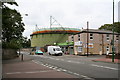
Gasholder, Wrythe Lane, Carshalton, Surrey
I had photographed this gasholder some 15 years ago, and was surprised to see it still in place. The original viewpoint was not possible owing to tree growth in the park. Image
Image: © Dr Neil Clifton
Taken: 5 Jul 2007
0.13 miles
7
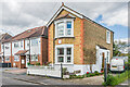
14 St Andrews Road
House built around the turn of the 19th/20th Centuries, one of only a few houses on the north side of St Andrews Road before fuller development happened in the c.1930s. The date/name plaque on the front of the building has been blanked off.
Image: © Ian Capper
Taken: 25 Apr 2023
0.13 miles
8
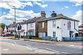
Brickfield Villas
Two pairs of semi-detached cottages in Wrythe Lane, with the nearer pair being marked on the 1896 25 inch map and the farther one being on the 1913 edition. The 1871 6 inch map shows a brick field behind the site.
Image: © Ian Capper
Taken: 25 Apr 2023
0.13 miles
9
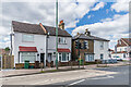
Brickfield Villas
Two pairs of semi-detached cottages in Wrythe Lane, with the farther pair being marked on the 1896 25 inch map and the nearer one being on the 1913 edition. The 1871 6 inch map shows a brick field behind the site.
Image: © Ian Capper
Taken: 25 Apr 2023
0.13 miles