IMAGES TAKEN NEAR TO
Wrythe Lane, CARSHALTON, SM5 2RP
Introduction
This page details the photographs taken nearby to Wrythe Lane, SM5 2RP by members of the Geograph project.
The Geograph project started in 2005 with the aim of publishing, organising and preserving representative images for every square kilometre of Great Britain, Ireland and the Isle of Man.

There are currently over 7.5m images from over14,400 individuals and you can help contribute to the project by visiting https://www.geograph.org.uk
Image Map
Images are licensed for reuse under creativecommons.org/licenses/by-sa/2.0
Notes
- Clicking on the map will re-center to the selected point.
- The higher the marker number, the further away the image location is from the centre of the postcode.
Image Listing (32 Images Found)
Images are licensed for reuse under creativecommons.org/licenses/by-sa/2.0
Image
Details
Distance
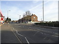
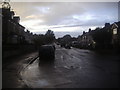
1
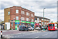
Wrythe Lane shopping parade
Shopping parade in Wrythe Lane, with the nearest block dating from the c.1950s.
Image: © Ian Capper
Taken: 25 Apr 2023
0.05 miles
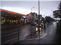
4
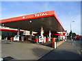
Petrol station, Wrythe Lane, Carshalton
Image: © Stacey Harris
Taken: 3 Apr 2011
0.08 miles
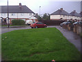
6
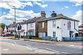
Brickfield Villas
Two pairs of semi-detached cottages in Wrythe Lane, with the nearer pair being marked on the 1896 25 inch map and the farther one being on the 1913 edition. The 1871 6 inch map shows a brick field behind the site.
Image: © Ian Capper
Taken: 25 Apr 2023
0.09 miles
8
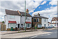
Brickfield Villas
Two pairs of semi-detached cottages in Wrythe Lane, with the farther pair being marked on the 1896 25 inch map and the nearer one being on the 1913 edition. The 1871 6 inch map shows a brick field behind the site.
Image: © Ian Capper
Taken: 25 Apr 2023
0.09 miles
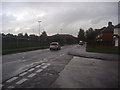
10
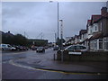
Wrythe Lane at the corner of Poulton Avenue
Image: © David Howard
Taken: 14 Oct 2013
0.14 miles