IMAGES TAKEN NEAR TO
Johnsons Close, CARSHALTON, SM5 2LU
Introduction
This page details the photographs taken nearby to Johnsons Close, SM5 2LU by members of the Geograph project.
The Geograph project started in 2005 with the aim of publishing, organising and preserving representative images for every square kilometre of Great Britain, Ireland and the Isle of Man.

There are currently over 7.5m images from over14,400 individuals and you can help contribute to the project by visiting https://www.geograph.org.uk
Image Map
Images are licensed for reuse under creativecommons.org/licenses/by-sa/2.0
Notes
- Clicking on the map will re-center to the selected point.
- The higher the marker number, the further away the image location is from the centre of the postcode.
Image Listing (62 Images Found)
Images are licensed for reuse under creativecommons.org/licenses/by-sa/2.0
Image
Details
Distance
1
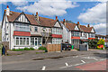
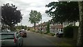
37 - 43 Nightingale Road
Two pairs of semi-detached houses dating from the early 20th Century, almost the only buildings shown on Nightingale Road on the 1913 25 inch map, compared with almost total development by the time of the 1935 edition.
Image: © Ian Capper
Taken: 25 Apr 2023
0.04 miles
2
Culvers Way
Housing estate first marked on the 1935 25 inch map.
Image: © Ian Capper
Taken: 25 Apr 2023
0.04 miles
3
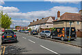
Junction of Nightingale Road & Strawberry Lane
Image: © Wilf Jones
Taken: 8 Feb 2007
0.05 miles
4
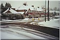
Strawberry Lane at the junction of Devana End
Image: © David Howard
Taken: 12 Jan 2014
0.10 miles
6
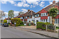
Strawberry Lane
Semi-detached houses in Strawberry Lane, a road partially developed on the 1935 25 inch map, including these.
Image: © Ian Capper
Taken: 25 Apr 2023
0.12 miles
7
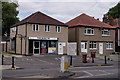
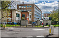
Liberal Democrat HQ for Carshalton and Wallington
Tom Brake was elected at the 1997 General Election.
Image: © Peter Trimming
Taken: 23 Jul 2018
0.16 miles
8
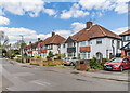
Strawberry Lane
Semi-detached houses in Strawberry Lane, a road partially developed on the 1935 25 inch map, with the ones here being slightly later, first being marked in outline on the 1944 6 inch map.
Image: © Ian Capper
Taken: 25 Apr 2023
0.16 miles
9
Carshalton College
Further education college on Nightingale Road.
Image: © Ian Capper
Taken: 25 Apr 2023
0.17 miles
10
Shopping parade opposite Wrythe Green, Carshalton
Another suburban shopping parade where some of the shops have closed. Note the handsome ornamental sewer vent on the Green. There are a number of these around Carshalton. The bus is on Route 151 from Worcester Park station to Wallington.
Image: © Dr Neil Clifton
Taken: 5 Jul 2007
0.17 miles