IMAGES TAKEN NEAR TO
Mill Lane, CARSHALTON, SM5 2LE
Introduction
This page details the photographs taken nearby to Mill Lane, SM5 2LE by members of the Geograph project.
The Geograph project started in 2005 with the aim of publishing, organising and preserving representative images for every square kilometre of Great Britain, Ireland and the Isle of Man.

There are currently over 7.5m images from over14,400 individuals and you can help contribute to the project by visiting https://www.geograph.org.uk
Image Map
Images are licensed for reuse under creativecommons.org/licenses/by-sa/2.0
Notes
- Clicking on the map will re-center to the selected point.
- The higher the marker number, the further away the image location is from the centre of the postcode.
Image Listing (192 Images Found)
Images are licensed for reuse under creativecommons.org/licenses/by-sa/2.0
Image
Details
Distance
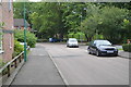
1
40 - 48 Mill Lane
Two terraces built c.2000 as part of the Grove Mill Place redevelopment behind the road.
Image: © Ian Capper
Taken: 25 Apr 2023
0.01 miles
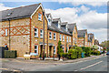
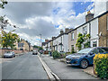
2
49 - 54 Mill Lane
Two late 19th Century three house terraces in Mill Lane, first marked on the 1896 25 inch map. The block beyond, 45 - 48 Mill Lane, was built c.2000 as part of the Grove Mill Place redevelopment behind the road. The 1871 6 inch map shows a four house terrace here.
Image: © Ian Capper
Taken: 25 Apr 2023
0.03 miles
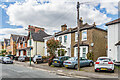
5
Mill Lane
Late 19th Century terraced housing in Mill Lane. The nearest block ha a name plaque "Grove Cottages"
Image: © Ian Capper
Taken: 7 Oct 2022
0.04 miles
6
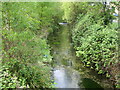
River Wandle in Carshalton
Viewed looking upstream from the Papermill Close footbridge.
Image: © Nigel Cox
Taken: 25 Apr 2007
0.05 miles
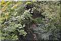
7

River Wandle from Mill Lane
This is the Carshalton branch of the River Wandle as opposed to the Beddington branch.
At the time of the Domesday Book in 1086 there were something like 13 water mills on the River Wandle for grinding corn. The heyday of the river's industrial use came in the early 18th century when there were 68 water wheels on the Wandle, an average of one every 300 metres. Even in 1805 it was said that the Wandle was the hardest worked river for its size in the world. As steam engines and electric power came in, use of the old water wheels gradually ceased. By the mid-19th century the Wandle milling industries, crippled by falling water levels and the spread of the steam engine, were on the verge of collapse. Decline in the second half of the 19th century was rapid.
Here looking upriver from Butter Hill, Ansell's Snuff Mill (which closed in 1896) and Denyer's Flour Mill used to stand on each side of the river. To the left of the river here is new housing. This used to be the site of a BP Chemicals factory which closed in 1991 and was demolished in 1992.
Image: © Marathon
Taken: 23 Aug 2013
0.05 miles
8
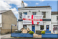
The Palmerston
Pub in Mill Street, dating from 1868 and historically the Lord Palmerston but with the name shortened in 2016.
Image: © Ian Capper
Taken: 25 Apr 2023
0.06 miles
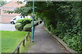
10
Papermill Close
The name alludes to the paper making industry that used to exist along the River Wandle.
Image: © N Chadwick
Taken: 23 Aug 2017
0.06 miles