IMAGES TAKEN NEAR TO
Reynolds Close, CARSHALTON, SM5 2AZ
Introduction
This page details the photographs taken nearby to Reynolds Close, SM5 2AZ by members of the Geograph project.
The Geograph project started in 2005 with the aim of publishing, organising and preserving representative images for every square kilometre of Great Britain, Ireland and the Isle of Man.

There are currently over 7.5m images from over14,400 individuals and you can help contribute to the project by visiting https://www.geograph.org.uk
Image Map
Images are licensed for reuse under creativecommons.org/licenses/by-sa/2.0
Notes
- Clicking on the map will re-center to the selected point.
- The higher the marker number, the further away the image location is from the centre of the postcode.
Image Listing (79 Images Found)
Images are licensed for reuse under creativecommons.org/licenses/by-sa/2.0
Image
Details
Distance
2
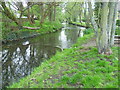
River Wandle near Culvers Avenue
Immediately below the Nightingale Road/Hackbridge Road bridge, the Wandle splits into two to form an island which is bisected by Culvers Avenue running east to west. The eastern branch is the main channel and is seen here looking downriver beyond the bridge where Culvers Avenue crosses it. The path on the right is the Wandle Trail.
Image: © Marathon
Taken: 2 May 2012
0.06 miles
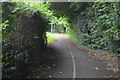
6
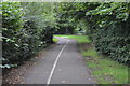
Wandle Trail near Beddington Corner
At this point the trail takes the form of a well surfaced shared-use path alongside the river.
Image: © Stephen Craven
Taken: 29 Aug 2011
0.06 miles
7
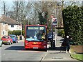
The route to prison
A bus marks time at the Reynolds Close terminus of route 80, whilst intending passengers wait for the driver to open the door for business.
Image: © Robin Webster
Taken: 28 Mar 2012
0.06 miles
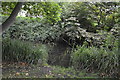
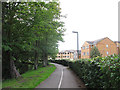
8
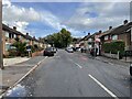
Culvers Avenue, Hackbridge
At the end of the road, under the trees, flows the river Wandle.
Image: © Nigel Thompson
Taken: 22 Oct 2022
0.07 miles
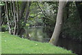
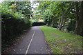
9
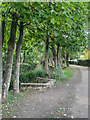
Alongside the River Wandle
Footpath alongside the River Wandle in Hackbridge.
Image: © Ian Capper
Taken: 7 Oct 2022
0.07 miles