IMAGES TAKEN NEAR TO
Monkleigh Road, MORDEN, SM4 4EP
Introduction
This page details the photographs taken nearby to Monkleigh Road, SM4 4EP by members of the Geograph project.
The Geograph project started in 2005 with the aim of publishing, organising and preserving representative images for every square kilometre of Great Britain, Ireland and the Isle of Man.

There are currently over 7.5m images from over14,400 individuals and you can help contribute to the project by visiting https://www.geograph.org.uk
Image Map
Images are licensed for reuse under creativecommons.org/licenses/by-sa/2.0
Notes
- Clicking on the map will re-center to the selected point.
- The higher the marker number, the further away the image location is from the centre of the postcode.
Image Listing (37 Images Found)
Images are licensed for reuse under creativecommons.org/licenses/by-sa/2.0
Image
Details
Distance
7
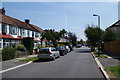
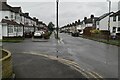
Cherrywood Lane
A residential area opposite Cannon Hill Common. There is supposed to be a chapel around here but I didn't find it.
Image: © Bill Boaden
Taken: 1 Aug 2011
0.16 miles
8
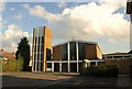
St John Fisher church, Morden
A modern Roman Catholic church on Cannon Hill Lane, seen across its car park.
Image: © Derek Harper
Taken: 16 Nov 2010
0.17 miles