IMAGES TAKEN NEAR TO
Woodstock Avenue, SUTTON, SM3 9EF
Introduction
This page details the photographs taken nearby to Woodstock Avenue, SM3 9EF by members of the Geograph project.
The Geograph project started in 2005 with the aim of publishing, organising and preserving representative images for every square kilometre of Great Britain, Ireland and the Isle of Man.

There are currently over 7.5m images from over14,400 individuals and you can help contribute to the project by visiting https://www.geograph.org.uk
Image Map
Images are licensed for reuse under creativecommons.org/licenses/by-sa/2.0
Notes
- Clicking on the map will re-center to the selected point.
- The higher the marker number, the further away the image location is from the centre of the postcode.
Image Listing (35 Images Found)
Images are licensed for reuse under creativecommons.org/licenses/by-sa/2.0
Image
Details
Distance
1
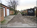
Service road off Elm Road West, Morden
Running behind the shops on Epsom Road
Image: © David Howard
Taken: 4 Feb 2013
0.05 miles

3

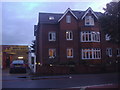
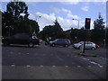
Epsom Road, Morden
At the junction of Elm Road West
Image: © David Howard
Taken: 4 Feb 2013
0.08 miles
4
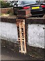
Boundary marker on the corner of Elm Road West
By the design this would have been made before 1964, and by the aging probably a lot earlier than that.
Image: © David Howard
Taken: 4 Feb 2013
0.09 miles
5
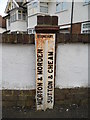
Old Boundary Marker
Parish Boundary Marker against a front garden wall at the junction of the A24 Epsom Road with Elm Road, Morden. On the boundary of Merton and Sutton. In raised lettering MERTON & MORDEN and SUTTON & CHEAM vertically side by side with BOUNDARY horizontally above both. See also https://www.geograph.org.uk/photo/3320140.
Milestone Society National ID: SY_MORD02pb
Image: © R Grant
Taken: 7 May 2019
0.09 miles
7

Stonecot Service Centre on Sutton Common Road
Image: © David Howard
Taken: 14 Oct 2013
0.11 miles
9
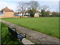
Sutton Common Park
The area of Sutton Common Park was formerly 'glebe' land administered for the benefit of the people of Sutton. In September 1926, Sutton Urban District Council Finance and Parliamentary Committee recommended a definitive offer of £4,000 for the land now known as Sutton Common Park. This was purchased in 1927. For the history and people's recollections of Sutton Common Park see http://www.foscp.org.uk/new/history.htm
This view looks across the park to the end of Hartland Way where it meets the path between Romany Gardens and Elm Road West. The path is on the other side of the wire fence.
Image: © Marathon
Taken: 13 Mar 2013
0.12 miles
10
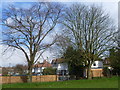
Hartland Way from Sutton Common Park
The area of Sutton Common Park was formerly 'glebe' land administered for the benefit of the people of Sutton. In September 1926, Sutton Urban District Council Finance and Parliamentary Committee recommended a definitive offer of £4,000 for the land now known as Sutton Common Park. This was purchased in 1927. For the history and people's recollections of Sutton Common Park see http://www.foscp.org.uk/new/history.htm
This view looks to the end of Hartland Way where it meets the path between Romany Gardens and Elm Road West.
Image: © Marathon
Taken: 13 Mar 2013
0.12 miles