IMAGES TAKEN NEAR TO
Baron Close, SUTTON, SM2 5NJ
Introduction
This page details the photographs taken nearby to Baron Close, SM2 5NJ by members of the Geograph project.
The Geograph project started in 2005 with the aim of publishing, organising and preserving representative images for every square kilometre of Great Britain, Ireland and the Isle of Man.

There are currently over 7.5m images from over14,400 individuals and you can help contribute to the project by visiting https://www.geograph.org.uk
Image Map
Images are licensed for reuse under creativecommons.org/licenses/by-sa/2.0
Notes
- Clicking on the map will re-center to the selected point.
- The higher the marker number, the further away the image location is from the centre of the postcode.
Image Listing (42 Images Found)
Images are licensed for reuse under creativecommons.org/licenses/by-sa/2.0
Image
Details
Distance
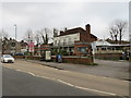
1
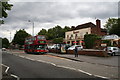
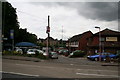
'The Belmont', Brighton Road, Belmont, Surrey
This large and busy public house stands on the main road southwards out of Sutton, (here the B2230). The bus in front on Route 280 is nearly at its terminus. It is a Plaxton-bodied Volvo (PVL 110) and has come from Tooting via Sutton, but one more stop and it will reach its Belmont terminus. A frequent service is provided, which is just as well, as the train only runs once an hour.
Image: © Dr Neil Clifton
Taken: 26 Jun 2007
0.01 miles
2
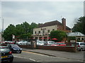
The Belmont public house, Belmont, Surrey
Image: © Stacey Harris
Taken: 3 Jun 2009
0.06 miles
3
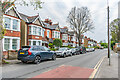
Cotswold Road
Row of semi-detached houses in Cotswold Road first marked on the 1913 25 inch map, although the road itself (at that time named Banstead Road, the current name not appearing until the 1956 1:1250 map) is much older.
Image: © Ian Capper
Taken: 26 Apr 2023
0.09 miles
5
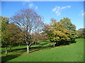
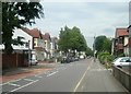
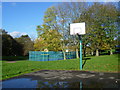
Belmont Park
Belmont Park is a small narrow park between Brighton Road (B2230) and the Sutton to Belmont railway line. Belmont station lies at its southern end. When this photograph was taken the autumn colours were just starting to come out.
Image: © Marathon
Taken: 4 Nov 2013
0.10 miles
6
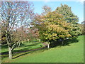
Belmont Park
Belmont Park is a small narrow park between Brighton Road (B2230) and the Sutton to Belmont railway line. Belmont station lies at its southern end. When this photograph was taken the autumn colours were just starting to come out.
Image: © Marathon
Taken: 4 Nov 2013
0.11 miles
7
The California, Belmont
The California pub in Belmont, on the outer fringe of south London.
This image was taken on a dull afternoon in January 2020.
Image: © Malc McDonald
Taken: 11 Jan 2020
0.11 miles
9
Belmont station, exterior, Down side
Apart from the British Rail sign on the pole, you would not expect to find a station down the road opposite. There's a car lot on the left, and on the right is a clinic and some private houses. But down at the end, if you persevere, you will find the 'station' - a comfortless single platform with a ticket machine and a bus shelter. But - it does still have trains, one an hour each way!
Image: © Dr Neil Clifton
Taken: 26 Jun 2007
0.12 miles
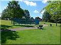
10
Belmont Park
Belmont Park is a small narrow park between Brighton Road (B2230) and the Sutton to Belmont railway line. Belmont station lies at this southern end.
Image: © Marathon
Taken: 4 Nov 2013
0.12 miles