IMAGES TAKEN NEAR TO
Bramley Road, SUTTON, SM1 4NN
Introduction
This page details the photographs taken nearby to Bramley Road, SM1 4NN by members of the Geograph project.
The Geograph project started in 2005 with the aim of publishing, organising and preserving representative images for every square kilometre of Great Britain, Ireland and the Isle of Man.

There are currently over 7.5m images from over14,400 individuals and you can help contribute to the project by visiting https://www.geograph.org.uk
Image Map
Images are licensed for reuse under creativecommons.org/licenses/by-sa/2.0
Notes
- Clicking on the map will re-center to the selected point.
- The higher the marker number, the further away the image location is from the centre of the postcode.
Image Listing (19 Images Found)
Images are licensed for reuse under creativecommons.org/licenses/by-sa/2.0
Image
Details
Distance
1
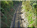
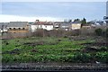
South Bermondsey Junction to Sutton line
Looking towards Sutton from bridge BTH1 1235 carrying King's Lane.
Image: © Robin Webster
Taken: 11 Apr 2012
0.15 miles
2
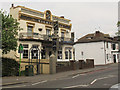
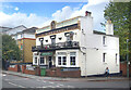
The Nightingale
A Casque Mark pub on Carshalton Road, Sutton.
Image: © Stephen Craven
Taken: 2 May 2015
0.16 miles
3
Carshalton: King's Lane
Some of Carshalton's ornamental sewer vent pipes are in rather obscure locations and not easy to track down. Here the view looks south in King's Lane, with Weihurst Gardens on the left. This pipe seems to have lost its crown, which would have been below the arrow.
Image: © Dr Neil Clifton
Taken: 16 Apr 2012
0.16 miles
4
The Nightingale, Carshalton Road
A Victorian pub on the corner of Carshalton and Lind Roads.
That second road is a clue to the pub's current name.
Jenny Lind was a famous mid 19th century singer known as "The Swedish Nightingale."
She was one of the earliest Celebrities in the modern sense, to the extent that there were pubs named after her, including, at one time, this one.
It's now called The Nightingale, so the connection is still there.
https://www.thenightingalesutton.co.uk/history
Image: © Des Blenkinsopp
Taken: 7 Oct 2024
0.16 miles
5
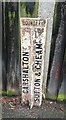
Old Boundary Marker
Parish Boundary Marker standing against a garden fence post on the south side of Westmead Road, just west of its junction with The Crescent and west of SY_CARSUT04pb in Carshalton. In raised lettering CARSHALTON and SUTTON & CHEAM side by side and vertically with BOUNDARY horizontally above both.
Milestone Society National ID: SY_CARSUT03pb
Image: © R Mills
Taken: 18 Feb 2020
0.16 miles
6
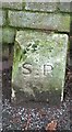
Old Boundary Marker
Parish Boundary Marker standing against a brick garden wall on the south side of Westmead Road, just west of its junction with The Crescent and west of SY_CARSUT03pb in Carshalton. Inscribed S P / 1894 for Sutton parish.
Milestone Society National ID: SY_CARSUT04pb
Image: © R Mills
Taken: 18 Feb 2020
0.17 miles
7
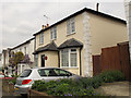
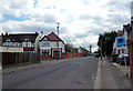
10 Alfred Road, Sutton
A modest suburban house where Horace Livens resided Image
Image: © Stephen Craven
Taken: 2 May 2015
0.17 miles
8
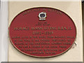
Plaque to Horace Livens
This plaque on 10 Alfred Road Image records that landscape artist Horace Livens resided here from 1902-1912.
Image: © Stephen Craven
Taken: 2 May 2015
0.17 miles
10
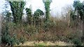
Wasteland between the lines, Sutton Junction
Image: © N Chadwick
Taken: 4 Feb 2018
0.20 miles