IMAGES TAKEN NEAR TO
Farmington Avenue, SUTTON, SM1 3PT
Introduction
This page details the photographs taken nearby to Farmington Avenue, SM1 3PT by members of the Geograph project.
The Geograph project started in 2005 with the aim of publishing, organising and preserving representative images for every square kilometre of Great Britain, Ireland and the Isle of Man.

There are currently over 7.5m images from over14,400 individuals and you can help contribute to the project by visiting https://www.geograph.org.uk
Image Map
Images are licensed for reuse under creativecommons.org/licenses/by-sa/2.0
Notes
- Clicking on the map will re-center to the selected point.
- The higher the marker number, the further away the image location is from the centre of the postcode.
Image Listing (26 Images Found)
Images are licensed for reuse under creativecommons.org/licenses/by-sa/2.0
Image
Details
Distance
2
Brickfield Villas
Two pairs of semi-detached cottages in Wrythe Lane, with the nearer pair being marked on the 1896 25 inch map and the farther one being on the 1913 edition. The 1871 6 inch map shows a brick field behind the site.
Image: © Ian Capper
Taken: 25 Apr 2023
0.06 miles
3
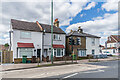
Brickfield Villas
Two pairs of semi-detached cottages in Wrythe Lane, with the farther pair being marked on the 1896 25 inch map and the nearer one being on the 1913 edition. The 1871 6 inch map shows a brick field behind the site.
Image: © Ian Capper
Taken: 25 Apr 2023
0.06 miles
5
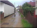
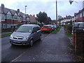
Erskine Close, Benhilton
It is only a dead end as they have put a bollard half way along, but being a private road they can do whatever they like. The council do the same anyway so probably not that different.
Image: © David Howard
Taken: 14 Oct 2013
0.10 miles
6
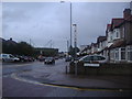
Wrythe Lane at the corner of Poulton Avenue
Image: © David Howard
Taken: 14 Oct 2013
0.11 miles
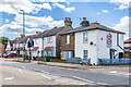
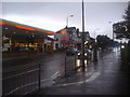
7
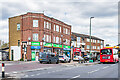
Wrythe Lane shopping parade
Shopping parade in Wrythe Lane, with the nearest block dating from the c.1950s.
Image: © Ian Capper
Taken: 25 Apr 2023
0.14 miles
8
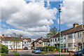
Laburnum Avenue
Houses in Laburnum Avenue. Part of the road is shown on the 1913 25 inch map as an isolated group named Laburnum Villas, with no other housing within 300m (see Image). Full development of the area had taken place by the 1935 edition. On the right is the sewer vent column in Image The houses in the background are in Erskine Road.
Image: © Ian Capper
Taken: 25 Apr 2023
0.14 miles
10
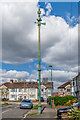
Sewer vent column, Laburnum Avenue
Sewer vent column in Laburnum Avenue, one of at least 31 such columns in the old Carshalton UDC area (see description below - this is no 14 on the map). This example has the arrow below the globe at the top of the column. Grade II listed - see https://historicengland.org.uk/listing/the-list/list-entry/1468776?section=official-list-entry. For wider views see Image and Image The houses in the background are in Erskine Road.
Image: © Ian Capper
Taken: 25 Apr 2023
0.15 miles