IMAGES TAKEN NEAR TO
Hawthorne Close, SUTTON, SM1 3LR
Introduction
This page details the photographs taken nearby to Hawthorne Close, SM1 3LR by members of the Geograph project.
The Geograph project started in 2005 with the aim of publishing, organising and preserving representative images for every square kilometre of Great Britain, Ireland and the Isle of Man.

There are currently over 7.5m images from over14,400 individuals and you can help contribute to the project by visiting https://www.geograph.org.uk
Image Map
Images are licensed for reuse under creativecommons.org/licenses/by-sa/2.0
Notes
- Clicking on the map will re-center to the selected point.
- The higher the marker number, the further away the image location is from the centre of the postcode.
Image Listing (17 Images Found)
Images are licensed for reuse under creativecommons.org/licenses/by-sa/2.0
Image
Details
Distance
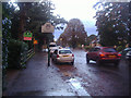
2
Rose Hill, Sutton
Looking towards St Helier.
Image: © David Howard
Taken: 26 Jan 2009
0.12 miles
3
Rose Hill Park West
Steep road on the west side of Rose Hill. The Eastern side is a gentle slope going down to the River Wandle about 1.5 km away.
Image: © James Emmans
Taken: 21 Jun 2019
0.19 miles
4
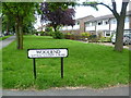
Sign for Sutton Garden Suburb
Sutton Garden Suburb was built between 1900 and 1918 along garden city lines. It was typical of subsequent housing in the district, supplying pleasant houses with gardens for middle-class families whose wage earners commuted into the City. This view of where Woodend meets All Saints Road shows more modern houses in the background, but Woodend and Greenhill, which Woodend leads to, are the chief roads in the garden suburb.
Image: © Marathon
Taken: 27 Jun 2012
0.21 miles
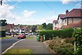
5

All Saints Road, Benhilton
Benhilton is the area north of Sutton and west of Carshalton, not really mentioned in name but on all the maps.
Image: © David Howard
Taken: 14 Oct 2013
0.22 miles
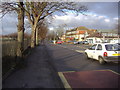
7
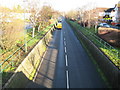
Benhilton: B2230 Angel Hill
Taken from the footbridge shown in Noel's Image this is the B2230 Angel Hill as it passes through a cutting between the housing estates in Benhilton.
Image: © Nigel Cox
Taken: 30 Jan 2008
0.23 miles
8
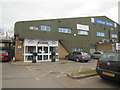
The Sports Village, Sutton
Multi Sport Venue in Sutton http://www.thesportsvillage.org.uk/
Image: © Paul Gillett
Taken: 20 Mar 2016
0.23 miles
9
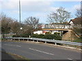
Angel Hill footbridge, Benhilton
The bridge crosses the B2230 (Rose Hill) where it runs in a cutting north of Sutton. The road in the foreground is Sutton Common Road.
Image: © Stephen Craven
Taken: 3 Mar 2011
0.24 miles
10
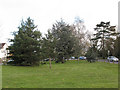
Evergreen trees on All Saints Green
Evergreens of various species on the green between All Saints Road and Angel Hill.
Image: © Stephen Craven
Taken: 3 Mar 2011
0.24 miles