IMAGES TAKEN NEAR TO
Rose Hill, SUTTON, SM1 3HH
Introduction
This page details the photographs taken nearby to Rose Hill, SM1 3HH by members of the Geograph project.
The Geograph project started in 2005 with the aim of publishing, organising and preserving representative images for every square kilometre of Great Britain, Ireland and the Isle of Man.

There are currently over 7.5m images from over14,400 individuals and you can help contribute to the project by visiting https://www.geograph.org.uk
Image Map
Images are licensed for reuse under creativecommons.org/licenses/by-sa/2.0
Notes
- Clicking on the map will re-center to the selected point.
- The higher the marker number, the further away the image location is from the centre of the postcode.
Image Listing (24 Images Found)
Images are licensed for reuse under creativecommons.org/licenses/by-sa/2.0
Image
Details
Distance
1
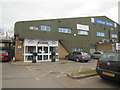
The Sports Village, Sutton
Multi Sport Venue in Sutton http://www.thesportsvillage.org.uk/
Image: © Paul Gillett
Taken: 20 Mar 2016
0.01 miles
2
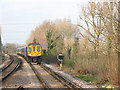
Train approaching Sutton Common
The train is formed of two 4-car class 319 "Thameslink" units and is on a service from Wimbledon to Luton (via Sutton and Blackfriars).
Image: © Stephen Craven
Taken: 3 Mar 2011
0.12 miles
3
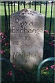
Old Milestone by the B2230, Rose Hill, Sutton and Cheam Parish
Carved stone post by the B2230 (was A217), Rose Hill, in parish of SUTTON AND CHEAM (SUTTON District), South of electricity pylon, by bus stop and shelter, set in own fenced area near to path, on North side of road. Surrey limestone pillar, erected by the Surrey & Sussex turnpike trust in the 19th century.
Inscription reads:- : Royal / Exchange / XI / Miles / Whitehall / X Miles :
Grade II Listed by Historic England, List Entry Number: 1474983 https://historicengland.org.uk/listing/the-list/list-entry/1474983
Milestone Society National ID: SY_LQR10
Image: © L Mead
Taken: 22 Aug 2002
0.14 miles
5
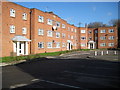
Sutton: Kedeston Court, Hurstcourt Road
The inscription in the stone tablet in the centre of the main façade of the block of flats reads:
S & C
1950
I am guessing therefore that these flats were originally built by the former Sutton & Cheam Council.
Image: © Nigel Cox
Taken: 30 Jan 2008
0.17 miles
6
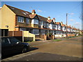
Sutton: Hurstcourt Road
Typical but attractive 1920s terraced houses with arched entranceways.
Image: © Nigel Cox
Taken: 30 Jan 2008
0.18 miles
7
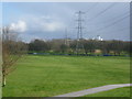
Looking across Rosehill Park West to St Helier Hospital
This view looks from the footbridge across Reigate Avenue (A217) and Rosehill Park West towards Greenshaw Wood and St Helier Hospital in the distance. Greenshaw Wood lies within the public park known as Rosehill Park East. A strip of oak woodland formerly ran in a crescent from the site of the present St Helier Hospital south to a larger tract of woodland depicted on the First Edition Ordnance Survey Map as Been Hill. This strip of woodland was felled before 1815 and Been Hill became the new suburb of Benhilton. Greenshaw Wood is all that remains of these former ancient woods showing up with exactly the same boundaries as today on the Ordnance survey Map of 1866. St Helier Hospital can be seen from large swathes of South London, being as it is on a hilltop and coloured white - see http://www.geograph.org.uk/photo/2981083 also http://www.geograph.org.uk/photo/3551975 and http://www.geograph.org.uk/photo/1884008
Image: © Marathon
Taken: 13 Mar 2013
0.18 miles
8
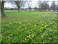
Daffodils alongside Rose Hill
This is Rosehill Park East alongside Rose Hill which is here on the right. Greenshaw Wood is up the hill to the left, just out of the picture.
Image: © Marathon
Taken: 13 Mar 2013
0.18 miles
9
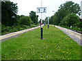
Sutton Common station
The Wimbledon to Sutton line was first proposed in the early 1880s with the intention of stimulating house building across the clay pastures between the two towns, which up until then had remained largely untouched. Lack of enthusiasm or downright opposition from established railway companies, particularly the London, Brighton & South Coast Railway, prevented any progress until after the First World War. The LBSCR went to such lengths to prove there was no need for a railway north of Sutton that when a Parliamentary committee in 1910 was considering a Bill for the line they produced a lady who explained that she had once tried to hail a bus which used to run between Wimbledon and Sutton. The conductor was so surprised that he failed to signal to the driver to stop, and the driver turned round to see what the lady was waving at.
The line finally opened in 1930, nearly 50 years after it was first proposed. The Wimbledon to Sutton line was designed for electric trains, with many inclines and sharp curves, although it hardly justified the drivers' nickname for it: "Wall of Death". Sutton Common, along with other stations on the line has a single central platform. Steps lead down from the road to the platform. The colourful flowers add a touch of brightness.
Image: © Marathon
Taken: 27 Jun 2012
0.20 miles
10
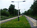
The platform on Sutton Common station
The Wimbledon to Sutton line was first proposed in the early 1880s with the intention of stimulating house building across the clay pastures between the two towns, which up until then had remained largely untouched. Lack of enthusiasm or downright opposition from established railway companies, particularly the London, Brighton & South Coast Railway, prevented any progress until after the First World War. The LBSCR went to such lengths to prove there was no need for a railway north of Sutton that when a Parliamentary committee in 1910 was considering a Bill for the line they produced a lady who explained that she had once tried to hail a bus which used to run between Wimbledon and Sutton. The conductor was so surprised that he failed to signal to the driver to stop, and the driver turned round to see what the lady was waving at.
The line finally opened in 1930, nearly 50 years after it was first proposed. The Wimbledon to Sutton line was designed for electric trains, with many inclines and sharp curves, although it hardly justified the drivers' nickname for it: "Wall of Death". Sutton Common, along with other stations on the line has a single central platform.
Image: © Marathon
Taken: 27 Jun 2012
0.20 miles