IMAGES TAKEN NEAR TO
Tate Road, SUTTON, SM1 2SY
Introduction
This page details the photographs taken nearby to Tate Road, SM1 2SY by members of the Geograph project.
The Geograph project started in 2005 with the aim of publishing, organising and preserving representative images for every square kilometre of Great Britain, Ireland and the Isle of Man.

There are currently over 7.5m images from over14,400 individuals and you can help contribute to the project by visiting https://www.geograph.org.uk
Image Map
Images are licensed for reuse under creativecommons.org/licenses/by-sa/2.0
Notes
- Clicking on the map will re-center to the selected point.
- The higher the marker number, the further away the image location is from the centre of the postcode.
Image Listing (19 Images Found)
Images are licensed for reuse under creativecommons.org/licenses/by-sa/2.0
Image
Details
Distance
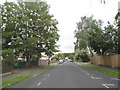
1
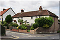
Bourne Way, Cheam
Seen from Gander Green Lane.
Image: © Peter Trimming
Taken: 9 Jun 2015
0.10 miles
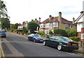
2
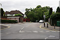
Quarry Road, Cheam
Located close to West Sutton railway station.
Image: © Peter Trimming
Taken: 9 Jun 2015
0.10 miles
3
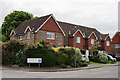
Shearwater Road, Cheam
Housing development, dating from 2000, seen from Gander Green Lane.
Image: © Peter Trimming
Taken: 9 Jun 2015
0.12 miles
4
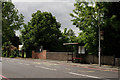
Cheam Road, Sutton
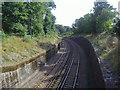
The railway line, on the loop from Sutton to Wimbledon, passes under the bridge beside the bus stop.
Image: © Peter Trimming
Taken: 9 Jun 2015
0.13 miles
5
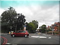
Mini-roundabout on Cheam Road
Gander Green Lane is on the left leading to London Road, North Cheam
Image: © David Howard
Taken: 15 Jun 2014
0.15 miles
6
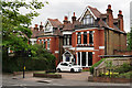
Dental Practice, Sutton
Located on Cheam Road, the practice comes well recommended.
Image: © Peter Trimming
Taken: 9 Jun 2015
0.15 miles
10

Old Milestone by the A232, Cheam Road, Sutton and Cheam parish
Carved stone post by the A232, in parish of SUTTON AND CHEAM (SUTTON District), Cheam Road, by No. 135, opposite Carlisle Road, back to boundary wall, set in pavement, on South side of road. Cheam stone, erected by the Reigate turnpike trust in the 19th century.
Inscription reads:-
: WESTMINSTER / BRIDGE / XII / MILES : : 1755 : : CORNHILL / XIII / MILES :
Carved benchmark and rivet on top.
Scheduled Monument.
List Entry Number: 1001999 https://historicengland.org.uk/listing/the-list/list-entry/1001999
Milestone Society National ID: SY_LQRA12.
Image: © JS Payne
Taken: 1 Oct 2010
0.18 miles