IMAGES TAKEN NEAR TO
Windsor Road, GERRARDS CROSS, SL9 8SS
Introduction
This page details the photographs taken nearby to Windsor Road, SL9 8SS by members of the Geograph project.
The Geograph project started in 2005 with the aim of publishing, organising and preserving representative images for every square kilometre of Great Britain, Ireland and the Isle of Man.

There are currently over 7.5m images from over14,400 individuals and you can help contribute to the project by visiting https://www.geograph.org.uk
Image Map
Images are licensed for reuse under creativecommons.org/licenses/by-sa/2.0
Notes
- Clicking on the map will re-center to the selected point.
- The higher the marker number, the further away the image location is from the centre of the postcode.
Image Listing (4 Images Found)
Images are licensed for reuse under creativecommons.org/licenses/by-sa/2.0
Image
Details
Distance
1
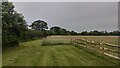
Farm near Hedgerley Park
This photo is taken from the B416 just south of the M40 Motorway.
Image: © David Hawgood
Taken: 22 Jun 2005
0.09 miles
2
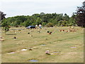
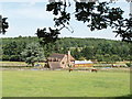
Parkside Cemetery of South Bucks District Council
This modern cemetery is designed for ease of maintenance. Memorials are flat in the ground to make it easy to mow the grass, and also to avoid the possible safety hazard of stones toppling over.
Image: © David Hawgood
Taken: 22 Jun 2005
0.12 miles
3
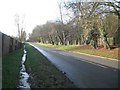
Fulmer: B416 Windsor Road
This section of the B416 once formed part of the A332. The Civil Parish boundary, between Fulmer to the left and Hedgerley to the right, runs down the middle of the road. Mounthill Wood is beyond the road to the right.
Image: © Nigel Cox
Taken: 22 Dec 2013
0.20 miles