IMAGES TAKEN NEAR TO
Chalfont Park, GERRARDS CROSS, SL9 0DZ
Introduction
This page details the photographs taken nearby to Chalfont Park, SL9 0DZ by members of the Geograph project.
The Geograph project started in 2005 with the aim of publishing, organising and preserving representative images for every square kilometre of Great Britain, Ireland and the Isle of Man.

There are currently over 7.5m images from over14,400 individuals and you can help contribute to the project by visiting https://www.geograph.org.uk
Image Map
Images are licensed for reuse under creativecommons.org/licenses/by-sa/2.0
Notes
- Clicking on the map will re-center to the selected point.
- The higher the marker number, the further away the image location is from the centre of the postcode.
Image Listing (6 Images Found)
Images are licensed for reuse under creativecommons.org/licenses/by-sa/2.0
Image
Details
Distance
1
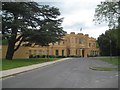
Chalfont St Peter: Chalfont Park House
The house is a Grade II Listed Building and the English Heritage website describes the exterior thus:-
"1755 by John Chute, altered by Nash c 1800 and remodelled by Salvin, 1836, in Gothic style. House of eight bays and two storeys. Cement rendered with battlemented parapets. Central bays project with central two storey porch flanked by battlemented turrets. Five bay conservatory to right of projecting centre bays. Bay windows to left of porch. Hood moulds to arched windows, some four-centred. Garden front with central full-height canted bay window, rendered with battlemented parapets to left of bay window, coped to right. Pointed arched windows with hoodmoulds."
The house has variously been a hotel, the headquarters of British Aluminium, and in 1965 it was briefly the Shrublands health clinic in the James Bond film Thunderball. It is currently the UK base of the multinational software company Citrix Systems.
Image: © Nigel Cox
Taken: 24 May 2015
0.00 miles
2
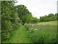
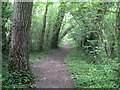
Chalfont St Peter: Gerrards Cross Golf Club course public footpath
This attractive part-lakeside public footpath runs between Chalfont St Peter and the bridleway and lane to Coldharbour Farm, along the eastern side of the Chalfont Park Lake and across the Gerrards Cross Golf Club fairways.
Image: © Nigel Cox
Taken: 24 May 2015
0.07 miles
3
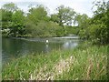
Chalfont St Peter: Chalfont Park Lake (2)
The lake was formed as part of the landscaping of Chalfont Park House by the damming up of a reach of the River Misbourne. This view was taken from the public footpath running along the eastern edge of the lake, and shows the channel separating the main island in the lake from the ground to the east.
Image: © Nigel Cox
Taken: 24 May 2015
0.13 miles
4
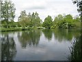
Chalfont St Peter: Chalfont Park Lake (1)
The lake was formed as part of the landscaping of Chalfont Park House by the damming up of a reach of the River Misbourne. This view was taken from the public footpath running along the eastern edge of the lake.
Image: © Nigel Cox
Taken: 24 May 2015
0.16 miles
5
Chafont St Peter: Chalfont Park Lake footpath
This attractive part-lakeside public footpath runs between Chalfont St Peter and the bridleway and lane to Coldharbour Farm, along the eastern side of the Chalfont Park Lake and across the Gerrards Cross Golf Club fairways.
Image: © Nigel Cox
Taken: 24 May 2015
0.21 miles
6
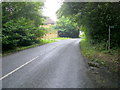
Footpaths off Amersham Road
Footpaths off Amersham Road to the right it heads down to A413 Amersham Road
Image: © Shaun Ferguson
Taken: 7 Aug 2009
0.24 miles