IMAGES TAKEN NEAR TO
Donkey Lane, BOURNE END, SL8 5RR
Introduction
This page details the photographs taken nearby to Donkey Lane, SL8 5RR by members of the Geograph project.
The Geograph project started in 2005 with the aim of publishing, organising and preserving representative images for every square kilometre of Great Britain, Ireland and the Isle of Man.

There are currently over 7.5m images from over14,400 individuals and you can help contribute to the project by visiting https://www.geograph.org.uk
Image Map
Images are licensed for reuse under creativecommons.org/licenses/by-sa/2.0
Notes
- Clicking on the map will re-center to the selected point.
- The higher the marker number, the further away the image location is from the centre of the postcode.
Image Listing (174 Images Found)
Images are licensed for reuse under creativecommons.org/licenses/by-sa/2.0
Image
Details
Distance
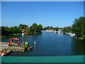
7
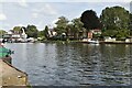
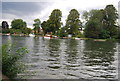
River Thames at Bourne End
Taken from the footbridge which is attached to the railway bridge, and which is used by the Thames Path to cross to the true left bank (if you are heading upstream, as I was!).
Image: © David Purchase
Taken: 16 Apr 2015
0.05 miles
8
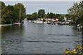
Orange Way after Wiltshire (418)
This is a view upstream from Bourne End Bridge. The footbridge is attached to the railway bridge on the upstream side. The railway bridge is currently being repaired and repainted.
Image: © Shazz
Taken: 31 Aug 2013
0.05 miles
9
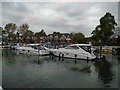
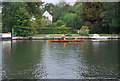
Upper Thames Sailing Club
At Bourne End http://www.utsc.org.uk/index.php?id=1
Image: © Paul Gillett
Taken: 4 May 2017
0.06 miles