IMAGES TAKEN NEAR TO
Chapman Lane, BOURNE END, SL8 5PB
Introduction
This page details the photographs taken nearby to Chapman Lane, SL8 5PB by members of the Geograph project.
The Geograph project started in 2005 with the aim of publishing, organising and preserving representative images for every square kilometre of Great Britain, Ireland and the Isle of Man.

There are currently over 7.5m images from over14,400 individuals and you can help contribute to the project by visiting https://www.geograph.org.uk
Image Map
Images are licensed for reuse under creativecommons.org/licenses/by-sa/2.0
Notes
- Clicking on the map will re-center to the selected point.
- The higher the marker number, the further away the image location is from the centre of the postcode.
Image Listing (13 Images Found)
Images are licensed for reuse under creativecommons.org/licenses/by-sa/2.0
Image
Details
Distance
1
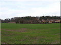
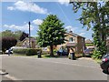
Farmland and houses, north of Bourne End
Looking over to Telston Close, with Unity House behind in the trees.
Image: © Andrew Smith
Taken: 1 Jan 2006
0.12 miles
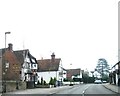
4
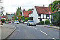
A4155 Marlow Road, Well End
Several grade II listed buildings are along the north side of the road.
Image: © Robin Webster
Taken: 9 Jun 2019
0.20 miles
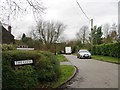
8
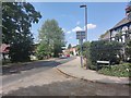
A4155 towards Marlow
Abbey Road junction on the Marlow Road in Well End.
Image: © James Emmans
Taken: 26 Jun 2020
0.21 miles
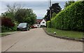
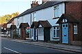
9
Wendover Road - Well End
Modern detached houses on bin day.
Image: © James Emmans
Taken: 26 Jun 2020
0.21 miles
10
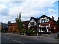
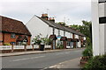
The Black Lion, Bourne End
Next door but one (far left of the picture) appears to be a disused chapel converted into a house.
Image: © Bikeboy
Taken: 21 Sep 2014
0.21 miles