IMAGES TAKEN NEAR TO
Blind Lane, BOURNE END, SL8 5LF
Introduction
This page details the photographs taken nearby to Blind Lane, SL8 5LF by members of the Geograph project.
The Geograph project started in 2005 with the aim of publishing, organising and preserving representative images for every square kilometre of Great Britain, Ireland and the Isle of Man.

There are currently over 7.5m images from over14,400 individuals and you can help contribute to the project by visiting https://www.geograph.org.uk
Image Map
Images are licensed for reuse under creativecommons.org/licenses/by-sa/2.0
Notes
- Clicking on the map will re-center to the selected point.
- The higher the marker number, the further away the image location is from the centre of the postcode.
Image Listing (3 Images Found)
Images are licensed for reuse under creativecommons.org/licenses/by-sa/2.0
Image
Details
Distance
1
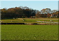
Paddocks at Flackwell Heath
At the south end of the village the houses suddenly stop and there is a series of paddocks before the arable farmland. Conveniently there is also a bridleway running along the nearest field boundary.
Image: © Graham Horn
Taken: 5 Dec 2010
0.18 miles
2
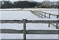
Paddocks at Flackwell Heath
All well covered with snow. One horse was even lying down. They must be hardier than we humans.
Image: © Graham Horn
Taken: 24 Dec 2010
0.23 miles
3
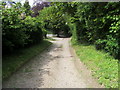
Lane passing Brantridge
Lane and Bridleway passing Brantridge heading to Ronald Wood
Image: © Shaun Ferguson
Taken: 16 May 2009
0.25 miles