IMAGES TAKEN NEAR TO
Sheepridge Lane, MARLOW, SL7 3SG
Introduction
This page details the photographs taken nearby to Sheepridge Lane, SL7 3SG by members of the Geograph project.
The Geograph project started in 2005 with the aim of publishing, organising and preserving representative images for every square kilometre of Great Britain, Ireland and the Isle of Man.

There are currently over 7.5m images from over14,400 individuals and you can help contribute to the project by visiting https://www.geograph.org.uk
Image Map
Images are licensed for reuse under creativecommons.org/licenses/by-sa/2.0
Notes
- Clicking on the map will re-center to the selected point.
- The higher the marker number, the further away the image location is from the centre of the postcode.
Image Listing (12 Images Found)
Images are licensed for reuse under creativecommons.org/licenses/by-sa/2.0
Image
Details
Distance
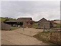
1
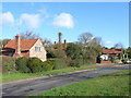
Sheepridge
Woodman's Cottage and the Crooked Billet pub. Despite its name Sheepridge is in a valley.
Image: © Andrew Smith
Taken: 8 Apr 2006
0.02 miles
2
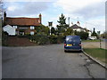
The Chiltern Way
The Chiltern Way footpath by the Crooked Billet pub in Sheepridge
Image: © Shaun Ferguson
Taken: 7 Mar 2008
0.02 miles
3
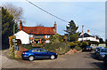
The Crooked Billet at Sheepridge
"Originally built in the 16th century as two cottages, then changed in 1850 to a simple Cider house."
From the pub website http://www.thecrookedbillet.com
There doesn't seem to be a car park as such, so parking is a bit random.
Image: © Des Blenkinsopp
Taken: 20 Feb 2017
0.08 miles
4
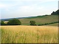
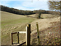
Grassland, Little Marlow
Looking down from the public footpath northwest of Sheepridge.
Image: © Andrew Smith
Taken: 24 Jul 2008
0.10 miles
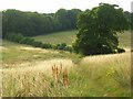
6
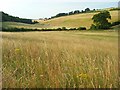
Grassland, Little Marlow
A dry valley west of Sheepridge. A public footpath follows the hedgerow across the valley.
Image: © Andrew Smith
Taken: 24 Jul 2008
0.17 miles
7
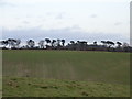
Farmland at Sheepridge
Sheepridge hamlet lies down in the valley, between the photographer and the trees.
Image: © Andrew Smith
Taken: 31 Dec 2005
0.17 miles
8
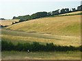
Grassland, Little Marlow
A dry valley west of Sheepridge. Cereal crops occupy the higher fields.
Image: © Andrew Smith
Taken: 24 Jul 2008
0.18 miles
9
New Farm, near Flackwell Heath
On the road from Little Marlow to Flackwell Heath.
Image: © David Hawgood
Taken: 6 Mar 2008
0.18 miles
10
Grassland, Little Marlow
On the footpath between Sheepridge and Bloom Wood.
Image: © Andrew Smith
Taken: 24 Jul 2008
0.18 miles