IMAGES TAKEN NEAR TO
Wycombe Road, MARLOW, SL7 3RA
Introduction
This page details the photographs taken nearby to Wycombe Road, SL7 3RA by members of the Geograph project.
The Geograph project started in 2005 with the aim of publishing, organising and preserving representative images for every square kilometre of Great Britain, Ireland and the Isle of Man.

There are currently over 7.5m images from over14,400 individuals and you can help contribute to the project by visiting https://www.geograph.org.uk
Image Map
Images are licensed for reuse under creativecommons.org/licenses/by-sa/2.0
Notes
- Clicking on the map will re-center to the selected point.
- The higher the marker number, the further away the image location is from the centre of the postcode.
Image Listing (11 Images Found)
Images are licensed for reuse under creativecommons.org/licenses/by-sa/2.0
Image
Details
Distance
1
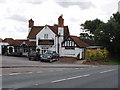
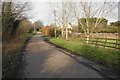
Three Horseshoes, Burroughs Grove
We enjoyed lunch here, particularly as they serve the local Marlow Rebellion beer http://www.rebellionbeer.co.uk/.
Image: © David Hawgood
Taken: 3 Sep 2008
0.03 miles
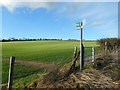
2
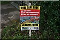
A local campaign
There is popular opposition to a planning application for a film studio which will occupy a large area on the other side of the A404.
Image: © Bill Boaden
Taken: 27 Jan 2024
0.07 miles
3
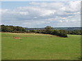
Pasture by the A404
View from road beside the Three Horseshoes pub at Burroughs Grove. The hedge across the photo is along the A404 from High Wycombe to Marlow and the M4 motorway.
Image: © David Hawgood
Taken: 3 Sep 2008
0.07 miles
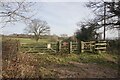
4
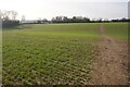
Chiltern Way near Burroughs Grove
Crossing a field which at this time of year is quite soft and sticky underfoot.
Image: © Bill Boaden
Taken: 27 Jan 2024
0.08 miles
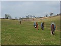
5
The Chiltern Way
The Chiltern Way heading away from Burroughs Grove towards Juniper Hill
Image: © Shaun Ferguson
Taken: 13 Sep 2008
0.09 miles
6
Chiltern Way leaving Burroughs Grove
Part of a 125 mile circular route, here heading east from Pump Lane North.
Image: © Bill Boaden
Taken: 27 Jan 2024
0.10 miles
7
The Chiltern Way at Burroughs Grove
The Chiltern Way manages to find a mainly rural route through the narrow belt of non urban land between Marlow and High Wycombe.
Image: © Des Blenkinsopp
Taken: 4 Feb 2017
0.11 miles
8
Paddocks, Little Marlow
In a dry valley at Burroughs Grove. Ploughed fields are higher up the valley.
Image: © Andrew Smith
Taken: 15 Mar 2008
0.19 miles
10
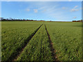
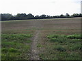
Tracks off the Chiltern Way
The Chiltern Way crosses a large arable field here at Burroughs Grove.
Image: © Des Blenkinsopp
Taken: 4 Feb 2017
0.21 miles