IMAGES TAKEN NEAR TO
Laburnum Close, MARLOW, SL7 3LF
Introduction
This page details the photographs taken nearby to Laburnum Close, SL7 3LF by members of the Geograph project.
The Geograph project started in 2005 with the aim of publishing, organising and preserving representative images for every square kilometre of Great Britain, Ireland and the Isle of Man.

There are currently over 7.5m images from over14,400 individuals and you can help contribute to the project by visiting https://www.geograph.org.uk
Image Map
Images are licensed for reuse under creativecommons.org/licenses/by-sa/2.0
Notes
- Clicking on the map will re-center to the selected point.
- The higher the marker number, the further away the image location is from the centre of the postcode.
Image Listing (5 Images Found)
Images are licensed for reuse under creativecommons.org/licenses/by-sa/2.0
Image
Details
Distance
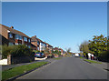
2
Hillside Road, Marlow
Suburban Marlow north of the town centre. Hillside Road at the junction with Woodland Way, where the hill is more obvious.
Image: © Des Blenkinsopp
Taken: 20 Apr 2013
0.12 miles
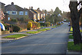
3

Marlow Bottom
Also the name of the road as it enters the mostly modern village at Bencombe Farm. The buildings on the right now house the Marlow Brewery.
Image: © Andrew Smith
Taken: 29 Mar 2008
0.22 miles
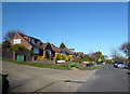
4
Seymour Park Road, Marlow
In the residential area on the northern outskirts of the town. This is the eastern end of the road where private sector housing is in contrast to the (ex-)local authority houses at the western ends.
Image: © Andrew Smith
Taken: 29 Mar 2008
0.23 miles
5
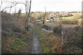
Bridleway to Marlow Bottom
Part of an old track linking Marlow with Marlow Bottom.
Image: © Bill Boaden
Taken: 27 Jan 2024
0.25 miles