IMAGES TAKEN NEAR TO
Market Square, MARLOW, SL7 1DA
Introduction
This page details the photographs taken nearby to Market Square, SL7 1DA by members of the Geograph project.
The Geograph project started in 2005 with the aim of publishing, organising and preserving representative images for every square kilometre of Great Britain, Ireland and the Isle of Man.

There are currently over 7.5m images from over14,400 individuals and you can help contribute to the project by visiting https://www.geograph.org.uk
Image Map
Images are licensed for reuse under creativecommons.org/licenses/by-sa/2.0
Notes
- Clicking on the map will re-center to the selected point.
- The higher the marker number, the further away the image location is from the centre of the postcode.
Image Listing (454 Images Found)
Images are licensed for reuse under creativecommons.org/licenses/by-sa/2.0
Image
Details
Distance
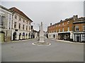
1
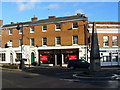
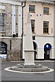
Market Square, Marlow
Roundabout with obelisk at the tri-point where three streets (High, Spittal and West) meet in central Marlow.
Image: © Colin Smith
Taken: 17 Jan 2010
0.01 miles
2
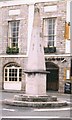
Old Milestone by the A4155, Market Square, Marlow
Carved stone post by the A4155, in parish of Marlow (Wycombe District), Market Square, at top of High Street, on a small circular island in the middle of the junction, in centre of road. Erected by the Reading & Hatfield turnpike trust in the 19th century.
Inscription reads:-
: MAIDENHEAD / 5 / READING / 14 / LONDON / 32 / BATH / 80 : : WYCOMBE / 5 / AYLESBURY / 22 / OXFORD / By STOKENCHURCH / 25 / HATFIELD / 36 : : HENLEY / 7½ / READING 15 / OXFORD/ by HENLEY / 30 / ABINGDON / 28 : : ERECTED / By the TRUSTEES of the / READING and HATFIELD / Road / September 1822 :
Grade II listed.
List Entry Number: 1125073 https://historicengland.org.uk/listing/the-list/list-entry/1125073
Milestone Society National ID: BU_RGHT15
Image: © A Rosevear & J Higgins
Taken: 23 Jul 2002
0.01 miles
3
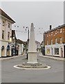
Obelisk Milestone by the A4155, High Street, Marlow
Carved stone obelisk milestone by the A4155, in parish of Marlow (Wycombe District), Market Square; at top of High Street, on a small circular island in the middle of the junction, in centre of road. Erected by the Reading & Hatfield Turnpike Trust in the 19th century.
Inscription reads:-
: MAIDENHEAD / 5 / READING / 14 / LONDON / 32 / BATH / 80 : : WYCOMBE / 5 / AYLESBURY / 22 / OXFORD / By STOKENCHURCH / 25 / HATFIELD / 36 : : ERECTED / By the TRUSTEES of the / READING and HATFIELD / Road / September 1822 :
Grade II listed. List Entry Number:1125073
https://historicengland.org.uk/listing/the-list/list-entry/1125073
Milestone Society National ID: BU_RGHT15.
Image: © Milestone Society
Taken: 6 Oct 2018
0.01 miles
4
Obelisk, Marlow
Grade II listed. https://www.britishlistedbuildings.co.uk/101125073-obelisk-marlow
Image: © N Chadwick
Taken: 16 Jul 2017
0.01 miles
5
Obelisk, Market Square
Grade II listed. https://historicengland.org.uk/listing/the-list/list-entry/1125073
Image: © N Chadwick
Taken: 26 May 2019
0.01 miles
8
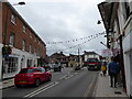
Looking along Spittal Street towards the obelisk
Image: © Basher Eyre
Taken: 5 Sep 2020
0.02 miles
9
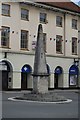
Marlow, obelisk
Obelisk milestone at the junction of High, West and Chapel Streets, showing the distances to Maidenhead, Reading (by two routes), London, Bath, Wycombe, Aylesbury, Oxford (by two routes), Hatfield, Henley & Abingdon. Erected 1822, listed by Historic England, and recently excellently refurbished by the Marlow Society: http://www.marlowsociety.org.uk/news_8/index.php http://www.imagesofengland.org.uk/details/default.aspx?id=46237
Image: © Mike Faherty
Taken: 6 Oct 2018
0.02 miles
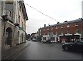
10
Looking from West Street across to High Street
Image: © Basher Eyre
Taken: 5 Sep 2020
0.02 miles