IMAGES TAKEN NEAR TO
Maidenhead Court Park, MAIDENHEAD, SL6 8HW
Introduction
This page details the photographs taken nearby to Maidenhead Court Park, SL6 8HW by members of the Geograph project.
The Geograph project started in 2005 with the aim of publishing, organising and preserving representative images for every square kilometre of Great Britain, Ireland and the Isle of Man.

There are currently over 7.5m images from over14,400 individuals and you can help contribute to the project by visiting https://www.geograph.org.uk
Image Map
Images are licensed for reuse under creativecommons.org/licenses/by-sa/2.0
Notes
- Clicking on the map will re-center to the selected point.
- The higher the marker number, the further away the image location is from the centre of the postcode.
Image Listing (11 Images Found)
Images are licensed for reuse under creativecommons.org/licenses/by-sa/2.0
Image
Details
Distance
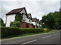
6
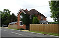
Houses on Lower Marlow Road, Maidenhead
Image: © David Howard
Taken: 12 Jul 2015
0.23 miles
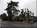
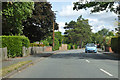
7

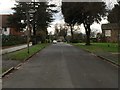
Maidenhead Suburbs - Sheephouse Road
Minor road in the north edges of Maidenhead.
Image: © James Emmans
Taken: 28 Jul 2020
0.23 miles
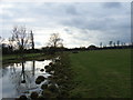
9
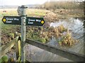
Cookham: White Brook (2)
White Brook is one of several watercourses that meander seemingly aimlessly across the flood plain of the River Thames north and upstream of Maidenhead. Here White Brook is in Cookham but the boundary with Maidenhead is very close, following the hedgerow on the right. The land on the left bank is the National Trust owned Widbrook Common, but on Victorian Ordnance Survey maps currently available online this is clearly shown as Whitebrook Common, hence the derivation of the present-day name.
Image: © Nigel Cox
Taken: 22 Jan 2015
0.24 miles
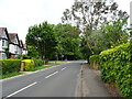
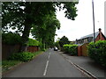
10
A4094 Lower Cookham Road
Towards Cookham and Bourne End.
Image: © Robin Webster
Taken: 9 Jun 2019
0.24 miles