IMAGES TAKEN NEAR TO
Ashley Park, MAIDENHEAD, SL6 8EZ
Introduction
This page details the photographs taken nearby to Ashley Park, SL6 8EZ by members of the Geograph project.
The Geograph project started in 2005 with the aim of publishing, organising and preserving representative images for every square kilometre of Great Britain, Ireland and the Isle of Man.

There are currently over 7.5m images from over14,400 individuals and you can help contribute to the project by visiting https://www.geograph.org.uk
Image Map
Images are licensed for reuse under creativecommons.org/licenses/by-sa/2.0
Notes
- Clicking on the map will re-center to the selected point.
- The higher the marker number, the further away the image location is from the centre of the postcode.
Image Listing (7 Images Found)
Images are licensed for reuse under creativecommons.org/licenses/by-sa/2.0
Image
Details
Distance
1
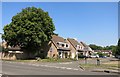
The Pagoda, Maidenhead
Sounds more interesting than it is.
No Chinese architecture. Just a street name.
Image: © Des Blenkinsopp
Taken: 30 Jul 2014
0.20 miles
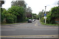
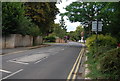
3
A4094 Lower Cookham Road
Towards Cookham and Bourne End.
Image: © Robin Webster
Taken: 9 Jun 2019
0.23 miles
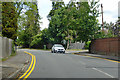
5
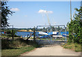
Maidenhead Sailing Club
On an old gravel pit right on the edge of town.
Image: © Des Blenkinsopp
Taken: 30 Jul 2014
0.24 miles
6
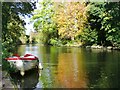
Maidenhead - River Thames
"Titchy" moored beside the Thames Path with Boulter's Island in midstream.
http://en.wikipedia.org/wiki/Thames_Path
Image: © Colin Smith
Taken: 19 Oct 2014
0.24 miles
7
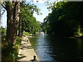
Above Boulter's Lock
Boat heading up the River Thames towards Cliveden Reach. The right bank is that of Boulter's Island. This is on the Thames Path National Trail and the London Green Belt Way.
Image: © Sean Davis
Taken: 21 May 2011
0.25 miles