IMAGES TAKEN NEAR TO
Sandisplatt Road, MAIDENHEAD, SL6 4NA
Introduction
This page details the photographs taken nearby to Sandisplatt Road, SL6 4NA by members of the Geograph project.
The Geograph project started in 2005 with the aim of publishing, organising and preserving representative images for every square kilometre of Great Britain, Ireland and the Isle of Man.

There are currently over 7.5m images from over14,400 individuals and you can help contribute to the project by visiting https://www.geograph.org.uk
Image Map
Images are licensed for reuse under creativecommons.org/licenses/by-sa/2.0
Notes
- Clicking on the map will re-center to the selected point.
- The higher the marker number, the further away the image location is from the centre of the postcode.
Image Listing (15 Images Found)
Images are licensed for reuse under creativecommons.org/licenses/by-sa/2.0
Image
Details
Distance
1
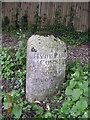
Old Milestone by the A4 in west Maidenhead
Carved stone post by the A4, in parish of Maidenhead (Windsor and Maidenhead District), Bath Road; 200m East of Maidenhead Thicket Roundabout, opposite Montrose Drive, on wide bank beneath Chestnut trees, on South side of road. Bath Road limestone pillar, erected by the Maidenhead turnpike trust in the 19th century.
Inscription reads:-
: TO / READING / 11 / MILES / BATH / 80 : : Parish of / WALTHAM / 1824 : : TO / HYDE PARK / CORNER / 28 / MILES / MAIDENHEAD / 2 / COLNBROOK / 11 :
Carved benchmark and rivet on top.
Grade II listed.
List Entry Number: 1117613 https://historicengland.org.uk/listing/the-list/list-entry/1117613
Milestone Society National ID: BE_LB28
Image: © A Rosevear
Taken: 28 Sep 2001
0.12 miles
2
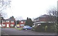
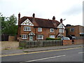
Silvertrees Drive, Maidenhead
Detached family houses such as these are to be found not only in the Altwood area of the town (where this shot was taken) but all over Maidenhead.
Image: © David Kemp
Taken: 2 Jan 2006
0.14 miles
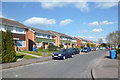
3
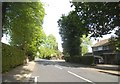
Altwood , Maidenhead
Altwood Close (which isn't a close at all!) pictured here is a bosky road of large detached houses typical of this part of Maidenhead.
Image: © David Kemp
Taken: 2 Jan 2006
0.14 miles
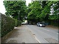
5

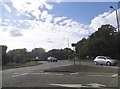
Turpins Green at the junction of Altwood Road
Image: © David Howard
Taken: 15 May 2016
0.15 miles
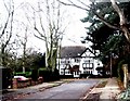
7
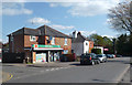
Highway Post Office
On the corner of Highway Road and Highway Avenue.
Image: © Des Blenkinsopp
Taken: 14 Apr 2014
0.17 miles