Old Milestone by the A4 in west Maidenhead
Introduction
The photograph on this page of Old Milestone by the A4 in west Maidenhead by A Rosevear as part of the Geograph project.
The Geograph project started in 2005 with the aim of publishing, organising and preserving representative images for every square kilometre of Great Britain, Ireland and the Isle of Man.

There are currently over 7.5m images from over 14,400 individuals and you can help contribute to the project by visiting https://www.geograph.org.uk
Old Milestone by the A4 in west Maidenhead
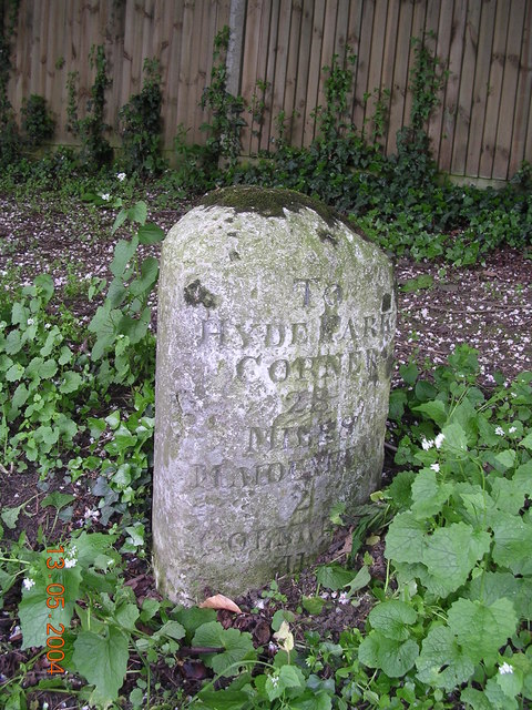
Image: © A Rosevear Taken: 28 Sep 2001
Carved stone post by the A4, in parish of Maidenhead (Windsor and Maidenhead District), Bath Road; 200m East of Maidenhead Thicket Roundabout, opposite Montrose Drive, on wide bank beneath Chestnut trees, on South side of road. Bath Road limestone pillar, erected by the Maidenhead turnpike trust in the 19th century. Inscription reads:- : TO / READING / 11 / MILES / BATH / 80 : : Parish of / WALTHAM / 1824 : : TO / HYDE PARK / CORNER / 28 / MILES / MAIDENHEAD / 2 / COLNBROOK / 11 : Carved benchmark and rivet on top. Grade II listed. List Entry Number: 1117613 https://historicengland.org.uk/listing/the-list/list-entry/1117613 Milestone Society National ID: BE_LB28
Images are licensed for reuse under creativecommons.org/licenses/by-sa/2.0
Image Location
Latitude
51.519213
Longitude
-0.759225