IMAGES TAKEN NEAR TO
Clare Road, MAIDENHEAD, SL6 4DW
Introduction
This page details the photographs taken nearby to Clare Road, SL6 4DW by members of the Geograph project.
The Geograph project started in 2005 with the aim of publishing, organising and preserving representative images for every square kilometre of Great Britain, Ireland and the Isle of Man.

There are currently over 7.5m images from over14,400 individuals and you can help contribute to the project by visiting https://www.geograph.org.uk
Image Map
Images are licensed for reuse under creativecommons.org/licenses/by-sa/2.0
Notes
- Clicking on the map will re-center to the selected point.
- The higher the marker number, the further away the image location is from the centre of the postcode.
Image Listing (23 Images Found)
Images are licensed for reuse under creativecommons.org/licenses/by-sa/2.0
Image
Details
Distance
9
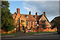
"Brocket" Boyn Hill Avenue
Seen here catching the last of the evening sunlight, Brocket is an Edwardian mansion built 1906-7 as a private residence, which it was until 1937. It is now owned by Maidenhead Council.
Listing and history on https://www.britishlistedbuildings.co.uk/101392401-brocket-boyn-hill-ward#.WvWTVq2ZORs
Image: © Des Blenkinsopp
Taken: 10 May 2018
0.17 miles