IMAGES TAKEN NEAR TO
Ascot Road, MAIDENHEAD, SL6 3LD
Introduction
This page details the photographs taken nearby to Ascot Road, SL6 3LD by members of the Geograph project.
The Geograph project started in 2005 with the aim of publishing, organising and preserving representative images for every square kilometre of Great Britain, Ireland and the Isle of Man.

There are currently over 7.5m images from over14,400 individuals and you can help contribute to the project by visiting https://www.geograph.org.uk
Image Map
Images are licensed for reuse under creativecommons.org/licenses/by-sa/2.0
Notes
- Clicking on the map will re-center to the selected point.
- The higher the marker number, the further away the image location is from the centre of the postcode.
Image Listing (9 Images Found)
Images are licensed for reuse under creativecommons.org/licenses/by-sa/2.0
Image
Details
Distance
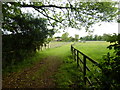
4
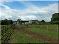
House and Paddock near Foxley Green Farm
Image: © James Emmans
Taken: 20 May 2017
0.15 miles
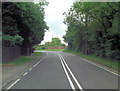
5
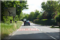
Slow on A330 towards Maidenhead
And slow it was, behind a cautious horsebox.
Image: © Robin Webster
Taken: 9 Jun 2019
0.20 miles
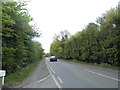
6
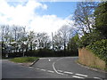
Forest Green at the junction of Ascot Road
Image: © David Howard
Taken: 3 May 2015
0.23 miles
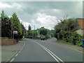
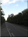
8
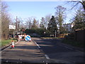
Road Works at Foxley Green
Temporary traffic lights at the junction of the A330 and B3024 [Forest Green Road] between Touchen End and Holyport.
Holyport Public School can be seen to the right.
Image: © Bill Johnson
Taken: 11 Dec 2007
0.23 miles