IMAGES TAKEN NEAR TO
Ascot Road, MAIDENHEAD, SL6 3JX
Introduction
This page details the photographs taken nearby to Ascot Road, SL6 3JX by members of the Geograph project.
The Geograph project started in 2005 with the aim of publishing, organising and preserving representative images for every square kilometre of Great Britain, Ireland and the Isle of Man.

There are currently over 7.5m images from over14,400 individuals and you can help contribute to the project by visiting https://www.geograph.org.uk
Image Map
Images are licensed for reuse under creativecommons.org/licenses/by-sa/2.0
Notes
- Clicking on the map will re-center to the selected point.
- The higher the marker number, the further away the image location is from the centre of the postcode.
Image Listing (7 Images Found)
Images are licensed for reuse under creativecommons.org/licenses/by-sa/2.0
Image
Details
Distance
1
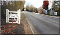
Village Sign, Touchen End
Along the A330. The map calls this Braywoodside.
Image: © Des Blenkinsopp
Taken: 9 Jan 2019
0.04 miles
2
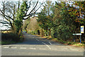
Sheepcote Lane, Touchen End
A residential lane flanked by widely spaced houses with large gardens. The header says this is Paley Street although I have just passed a sign saying Touchen End and the map calls it Braywoodside.
I guess the locals know where they live.
Image: © Des Blenkinsopp
Taken: 9 Jan 2019
0.05 miles
3
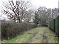
Connecting path
A useful short path connects from this track to the road to Paley Street.
Image: © don cload
Taken: 1 Feb 2011
0.10 miles
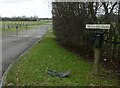
4

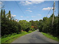
Sheepcote Lane
Looking east towards the junction with the A330.
Image: © Andrew Smith
Taken: 13 Nov 2005
0.15 miles
6
Paley Street: Sheepcote Lane
Viewed looking in the direction of the B3024 road.
Image: © Nigel Cox
Taken: 14 Sep 2008
0.24 miles
7
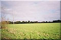
Farmland, Braywoodside
Looking northeast towards Sheepcote Lane
Image: © Andrew Smith
Taken: 13 Nov 2005
0.24 miles