IMAGES TAKEN NEAR TO
Sheepcote Lane, MAIDENHEAD, SL6 3JU
Introduction
This page details the photographs taken nearby to Sheepcote Lane, SL6 3JU by members of the Geograph project.
The Geograph project started in 2005 with the aim of publishing, organising and preserving representative images for every square kilometre of Great Britain, Ireland and the Isle of Man.

There are currently over 7.5m images from over14,400 individuals and you can help contribute to the project by visiting https://www.geograph.org.uk
Image Map
Images are licensed for reuse under creativecommons.org/licenses/by-sa/2.0
Notes
- Clicking on the map will re-center to the selected point.
- The higher the marker number, the further away the image location is from the centre of the postcode.
Image Listing (16 Images Found)
Images are licensed for reuse under creativecommons.org/licenses/by-sa/2.0
Image
Details
Distance
1
Paley Street: Sheepcote Lane
Viewed looking in the direction of the B3024 road.
Image: © Nigel Cox
Taken: 14 Sep 2008
0.03 miles
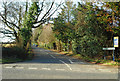
2
Sheepcote Lane
Looking east towards the junction with the A330.
Image: © Andrew Smith
Taken: 13 Nov 2005
0.11 miles

4
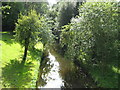
Paley Street: The Cut
The Cut rises to the north-east of Bracknell and then flows west, then north then north-eastwards through Paley Street towards Bray and the River Thames. It is seen here looking upstream from the B3024 road bridge.
Image: © Nigel Cox
Taken: 14 Sep 2008
0.18 miles
5
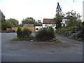
No longer the Bridge House, Paley Street
The empty car park is because it is derelict
Image: © David Howard
Taken: 3 May 2015
0.19 miles
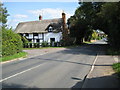
6
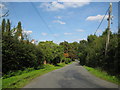
Sheepcote Lane, Touchen End
A residential lane flanked by widely spaced houses with large gardens. The header says this is Paley Street although I have just passed a sign saying Touchen End and the map calls it Braywoodside.
I guess the locals know where they live.
Image: © Des Blenkinsopp
Taken: 9 Jan 2019
0.19 miles
7
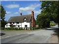
Corner Cottage, Paley Street
A 16th century cottage on the corner of Paley Street and the B3024.
Image: © Andrew Smith
Taken: 28 Jun 2008
0.20 miles
8
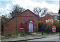
Disused Chapel For Sale
This is opposite the derelict church hall shown in Image Both premises have Sale Agreed signs outside. The sign over the door says Norman James Court.
Image: © Des Blenkinsopp
Taken: 14 Apr 2018
0.20 miles
9
Paley Street: The B3024 road
The B3024 road between Touchen-end and Twyford passes through Paley Street. The 1881 Ordnance Survey map shows five wells within about two hundred metres of this location.
Image: © Nigel Cox
Taken: 14 Sep 2008
0.21 miles
10
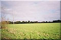
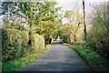
Farmland, Braywoodside
Looking northeast towards Sheepcote Lane
Image: © Andrew Smith
Taken: 13 Nov 2005
0.22 miles