IMAGES TAKEN NEAR TO
Sycamore Close, MAIDENHEAD, SL6 3HU
Introduction
This page details the photographs taken nearby to Sycamore Close, SL6 3HU by members of the Geograph project.
The Geograph project started in 2005 with the aim of publishing, organising and preserving representative images for every square kilometre of Great Britain, Ireland and the Isle of Man.

There are currently over 7.5m images from over14,400 individuals and you can help contribute to the project by visiting https://www.geograph.org.uk
Image Map
Images are licensed for reuse under creativecommons.org/licenses/by-sa/2.0
Notes
- Clicking on the map will re-center to the selected point.
- The higher the marker number, the further away the image location is from the centre of the postcode.
Image Listing (6 Images Found)
Images are licensed for reuse under creativecommons.org/licenses/by-sa/2.0
Image
Details
Distance
1
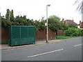
Rugged Bus Stop
Glassless bus stop. You can't vandalize it, but then it already looks awful.
Image: © Martyn Davies
Taken: 18 Aug 2009
0.12 miles
2
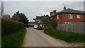
Old Farm Workers Cottages
These houses were once tied to Lillibrooke Manor.
Image: © James Emmans
Taken: 10 Apr 2015
0.21 miles
3
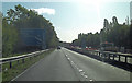
A404(M) approaches junction 9a
This carriageway used to form part of the eastbound M4, when the motorway terminated at Maidenhead Thicket. Now it's showing its age and needs some TLC and tarmac.
Image: © Stuart Logan
Taken: 14 Sep 2011
0.23 miles
4
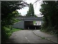
A404M Underpass
Footpath and bridleway linking Cox Green with Maidenhead under the busy bypass.
Image: © Martyn Davies
Taken: 18 Aug 2009
0.24 miles
5
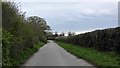
Ockwells Road
Ockwells road marks the end of suburbia and the start of the countryside. It is now a one way road to stop people using the road as a 'rat run', the speed limit remains at 40mph.
Image: © James Emmans
Taken: 18 Apr 2016
0.25 miles
6
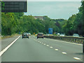
Cox Green : The A404(M)
Between Junction 9B (The Thicket) and 9A (Cox Green).
Image: © Lewis Clarke
Taken: 18 Jul 2019
0.25 miles