IMAGES TAKEN NEAR TO
Bray Close, MAIDENHEAD, SL6 2BL
Introduction
This page details the photographs taken nearby to Bray Close, SL6 2BL by members of the Geograph project.
The Geograph project started in 2005 with the aim of publishing, organising and preserving representative images for every square kilometre of Great Britain, Ireland and the Isle of Man.

There are currently over 7.5m images from over14,400 individuals and you can help contribute to the project by visiting https://www.geograph.org.uk
Image Map
Images are licensed for reuse under creativecommons.org/licenses/by-sa/2.0
Notes
- Clicking on the map will re-center to the selected point.
- The higher the marker number, the further away the image location is from the centre of the postcode.
Image Listing (70 Images Found)
Images are licensed for reuse under creativecommons.org/licenses/by-sa/2.0
Image
Details
Distance
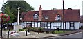
2
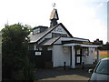
Bray: The Village Hall
The Village Hall was built in 1923. One website listing halls that can be hired in the Maidenhead area curiously lists this one as being capable of "holding 100 people (80 comfortably)".
(NB On a personal note this was not the greatest view possible of the hall but I was constrained by the parked cars in front and the low bright sunshine.)
Image: © Nigel Cox
Taken: 14 Sep 2008
0.04 miles
3
Bray Village Hall
See also Nigel Cox's Image I like the caption he's put with it.
Image: © Des Blenkinsopp
Taken: 29 Oct 2018
0.04 miles
4
Britain in Bloom
Outside this house is displayed the results of Bray's entry in the Britain in Bloom competition for every year since 1990.
Image: © don cload
Taken: 6 Mar 2012
0.05 miles
5
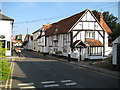
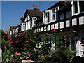
Bray: High Street
The narrowness of Bray's High Street here has necessitated the introduction of a traffic restriction with priority given to vehicles coming in the opposite direction. The front doors of the half-timbered houses on the right that face out onto the street are so low that the lintels are below the shoulder height of an average man. Image is visible in the distance.
Image: © Nigel Cox
Taken: 14 Sep 2008
0.05 miles
6
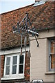
Tools of the trade
The interesting sign of the Fat Duck incorporates a webbed foot, feather and bill. Certainly from the outside this is a modest establishment although owned by a culinary megastar and appropriately priced.
Image: © Chris Allen
Taken: 27 Oct 2007
0.06 miles
7
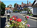
High Street, Bray
Looking north over flowers to catch the eye of "Britain in Bloom" judges, and past black & white half-timbered houses, towards the parish church of St Michael. The church dates from 1293, replacing a Norman church at the same location. The renowned 'Vicar of Bray' held the living here from 1667AD, under five separate monarchs, and is buried in the nave.
Image: © Colin Smith
Taken: 4 Aug 2007
0.06 miles
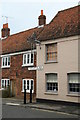
8
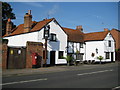
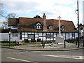
Bray: The Crown
Or The Crown at Bray to give it its proper name. This is another old white-washed half-timbered building in Bray.
Image: © Nigel Cox
Taken: 14 Sep 2008
0.06 miles
9
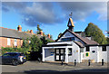
War Memorial, Bray
Bray village centre and War Memorial.
Image: © Len Williams
Taken: 3 Sep 2015
0.06 miles
10
Exclusive restaurant
The cream building with the interesting sign (q.v.) is the Fat Duck, one of the very best restaurants in the UK and owned by the charismatic Heston Blumenthal. The ordinary a la carte is "eighty pounds" and the eclectic tasting menu is "one hundred and fifteen pounds" - nothing so plebeian as £80 and £115 on these menus.
Image: © Chris Allen
Taken: 27 Oct 2007
0.06 miles