IMAGES TAKEN NEAR TO
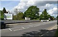
Bath Road, MAIDENHEAD, SL6 0AP
Introduction
This page details the photographs taken nearby to Bath Road, SL6 0AP by members of the Geograph project.
The Geograph project started in 2005 with the aim of publishing, organising and preserving representative images for every square kilometre of Great Britain, Ireland and the Isle of Man.

There are currently over 7.5m images from over14,400 individuals and you can help contribute to the project by visiting https://www.geograph.org.uk
Image Map
Images are licensed for reuse under creativecommons.org/licenses/by-sa/2.0
Notes
- Clicking on the map will re-center to the selected point.
- The higher the marker number, the further away the image location is from the centre of the postcode.
Image Listing (49 Images Found)
Images are licensed for reuse under creativecommons.org/licenses/by-sa/2.0
Image
Details
Distance
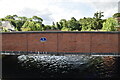
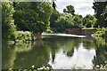
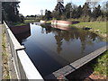
2
Jubilee River: Maidenhead
This is the view looking downstream towards the A4 road bridge. The man-made Jubilee River was designed to provide flood protection for property in Maidenhead, Windsor, and Eton.
Image: © Nigel Cox
Taken: 28 Oct 2005
0.03 miles
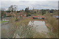
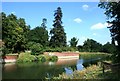
9
Jubilee River, Taplow
Flood prevention scheme seen from a footbridge beside the Bath Road.
http://www.jubileeriver.co.uk/
Image: © Colin Smith
Taken: 28 Mar 2012
0.05 miles
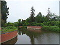
10
The Jubilee River
The Environment Agency's flood relief channel which leaves the Thames above Boulters Lock a couple of kms upstream of here.
Image: © Des Blenkinsopp
Taken: 29 Jul 2014
0.06 miles