IMAGES TAKEN NEAR TO
Buckhurst Road, ASCOT, SL5 7QE
Introduction
This page details the photographs taken nearby to Buckhurst Road, SL5 7QE by members of the Geograph project.
The Geograph project started in 2005 with the aim of publishing, organising and preserving representative images for every square kilometre of Great Britain, Ireland and the Isle of Man.

There are currently over 7.5m images from over14,400 individuals and you can help contribute to the project by visiting https://www.geograph.org.uk
Image Map
Images are licensed for reuse under creativecommons.org/licenses/by-sa/2.0
Notes
- Clicking on the map will re-center to the selected point.
- The higher the marker number, the further away the image location is from the centre of the postcode.
Image Listing (21 Images Found)
Images are licensed for reuse under creativecommons.org/licenses/by-sa/2.0
Image
Details
Distance
3

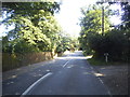
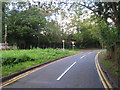
The B383, Buckhurst Road
Buckhurst Road runs from Sunninghill towards Windsor. Silwood Park is on the right.
Image: © Alan Hunt
Taken: 6 Apr 2013
0.03 miles
5
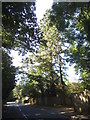
Mill Lane junction
Onto Buckhurst Road
Image: © Oast House Archive
Taken: 6 Oct 2010
0.05 miles
6
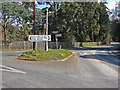
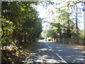
Exclusive in every direction
The junction between Cheapside Road and the B383, Buckhurst Road. Much of the land around here is Crown Estate.
Image: © Alan Hunt
Taken: 6 Apr 2013
0.11 miles
7
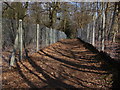
Church Path, Silwood Park
The path that runs across Silwood Park from Buckhurst Road to Sunninghill church. Silwood Park is the rural campus of Imperial College. The fencing is to prevent encroachment onto the ecological research projects that are carried out in the grounds.
Image: © Alan Hunt
Taken: 6 Apr 2013
0.11 miles
8
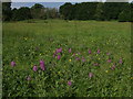
Heronsbrook Meadow Silwood Park
Southern marsh orchids (Dactylorhiza praetermissa) in the wet meadow known as Heronsbrook in Silwood Park. Note the skeletons of dead elm in the distance
Image: © Mick Crawley
Taken: 12 Jun 2004
0.12 miles
9
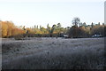
Pond Field Silwood Park
This wet grassland was formerly rich in orchids, but the field has progressivley dried out and is now species-poor. The eponymous Pond is typically dry all year round these days. The houses in the distance, built in the early 1950s, are on Buckhurst Road. The Wellingtonias (Sequoiadendron giganteum) on the skyline are in Buckhurst Park (Crown Estate), home to the King of Jordan.
Image: © Mick Crawley
Taken: 12 Dec 2010
0.12 miles
10
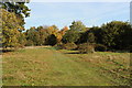
Nash's Slope Silwood Park
An early autumn view along the grass track separating Nash's Field (to the left) from Pond Field (to the right). The oaks and birches to the right of centre recruited inside rabbit fences erected in 1996 (i.e. 17 years before the picture was taken)
Image: © Mick Crawley
Taken: 13 Nov 2013
0.15 miles