IMAGES TAKEN NEAR TO
Exchange Road, ASCOT, SL5 7AW
Introduction
This page details the photographs taken nearby to Exchange Road, SL5 7AW by members of the Geograph project.
The Geograph project started in 2005 with the aim of publishing, organising and preserving representative images for every square kilometre of Great Britain, Ireland and the Isle of Man.

There are currently over 7.5m images from over14,400 individuals and you can help contribute to the project by visiting https://www.geograph.org.uk
Image Map
Images are licensed for reuse under creativecommons.org/licenses/by-sa/2.0
Notes
- Clicking on the map will re-center to the selected point.
- The higher the marker number, the further away the image location is from the centre of the postcode.
Image Listing (25 Images Found)
Images are licensed for reuse under creativecommons.org/licenses/by-sa/2.0
Image
Details
Distance
1
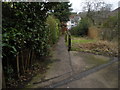
Exchange Road becomes a footpath
Exchange Road appears to have been built in two halves, with the middle link being this footpath.
Image: © David Howard
Taken: 3 Feb 2013
0.01 miles
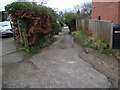
3
Exchange Road, Sunninghill
The road to Ascot telephone exchange.
Image: © David Howard
Taken: 3 Feb 2013
0.04 miles
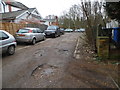
4
17 Exchange Road Sunninghill
This was student flats (one couple on each of the three floors) in the early 1970s
Image: © Mick Crawley
Taken: 14 Jun 1972
0.04 miles
5
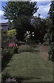
The back garden of 17 Exchange Road Sunninghill
The students who lived here were more than average keen gardeners
Image: © Mick Crawley
Taken: 18 Jun 1972
0.05 miles
6
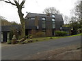
Modern house on Lower Village Road, Sunninghill
Modern is actually a type of design rather than age related in respect to architecture. Therefore many new houses are not modern while many modern houses are around 100 years old from the rise of the Bauhaus Movement in Germany onwards. This was probably built around 1980.
Image: © David Howard
Taken: 3 Feb 2013
0.06 miles
7
The Forge (86a) Upper Village Road during demolition
The site was cleared in June 1995
Image: © Mick Crawley
Taken: 14 Jun 1995
0.06 miles
8
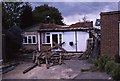
The Forge 86a Upper Village Road Sunninghill
The house was built 25 years ago following demolition of the original factory (The Forge). The climber on the right is Solanum jasminoides 'Album', still flowering profusely in October.
Image: © Mick Crawley
Taken: 6 Oct 2021
0.06 miles
9
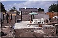
The Forge (86a) Upper Village Road under construction
In July 1996 the floor was laid out and the builders had installed a picnic area in what was to be the kitchen
Image: © Mick Crawley
Taken: 16 Jul 1996
0.06 miles
10
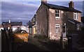
86 Upper Village Road Sunninghill before extension
The Forge (to the left) in the process of demolition in early 1995
Image: © Mick Crawley
Taken: 13 Feb 1995
0.07 miles