IMAGES TAKEN NEAR TO
Darwin Road, SLOUGH, SL3 8DG
Introduction
This page details the photographs taken nearby to Darwin Road, SL3 8DG by members of the Geograph project.
The Geograph project started in 2005 with the aim of publishing, organising and preserving representative images for every square kilometre of Great Britain, Ireland and the Isle of Man.

There are currently over 7.5m images from over14,400 individuals and you can help contribute to the project by visiting https://www.geograph.org.uk
Image Map
Images are licensed for reuse under creativecommons.org/licenses/by-sa/2.0
Notes
- Clicking on the map will re-center to the selected point.
- The higher the marker number, the further away the image location is from the centre of the postcode.
Image Listing (117 Images Found)
Images are licensed for reuse under creativecommons.org/licenses/by-sa/2.0
Image
Details
Distance
2
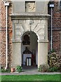
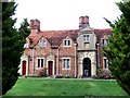
Seymour Almshouses, Langley Marish: porch with umbrella
Seen from the churchyard. I don't know who manages these almshouses these days, but they seem to be in use as sheltered accommodation for active old folk - not so very different from their original purpose. This is the porch at the middle of the row - I can see a red umbrella, and it looks as if somebody likes a bit of gardening.
My only reservation is this: when you get old, would you choose to wake up each morning looking out at the churchyard ?
Image: © Stefan Czapski
Taken: 15 Mar 2011
0.14 miles
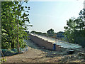
3
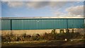
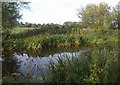
Slough arm of the Grand Union Canal
Looking away from Trenches Bridge; this is the start of a three kilometre straight stretch. Named footpath trails run on either side here; the Colne Valley Trail on the left, and the Grand Union Canal Walk on the right.
Image: © Derek Harper
Taken: 20 Sep 2010
0.14 miles
4
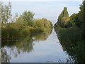
Slough Arm, Grand Union Canal
East of bridge 8.
Image: © Robin Webster
Taken: 21 Jul 2013
0.15 miles
5
The Seymour Almshouses, Langley Marish, seen from the churchyard
These little 17th century cottages (they date from about 1680) still serve much their original purpose - as accommodation for old people. Architecturally, the red-brick parts are vernacular in style, much as they would have been if built a century earlier. The chimney stacks are set diagonally, as they would have been in Tudor times. But the doorways and the two-storey porch are a bit more 'architectural' - there is some Classical influence.
Those down-pipes seem a bit out of character - mightn't it be better to paint them black ? In earlier days there may have been chutes projecting from the eaves to throw rainwater clear - as at Kelmscott Manor in Oxfordshire: Image
For a view from the road see http://www.geograph.org.uk/photo/2309314
Image: © Stefan Czapski
Taken: 15 Mar 2011
0.15 miles
6
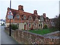
Seymour Almshouses, Langley Marish
These almshouses stand on the north side of the churchyard, while the somewhat older Kederminster almshouses stand on its south side http://www.geograph.org.uk/photo/2309292. The two sets of buildings are generally similar - redbrick cottages, with gabled dormers. An inscription on the Kederminster buildings dates them to 1617, while these are said to date from the 1670's and 80's http://www.britishlistedbuildings.co.uk/en-38733-12-14-16-18-20-22-slough.
For a view from the churchyard see: http://www.geograph.org.uk/photo/2310827
Image: © Stefan Czapski
Taken: 15 Mar 2011
0.15 miles
7
Path improvements
A new ramp up to the railway bridge is being built.
Image: © Robin Webster
Taken: 21 Jul 2013
0.15 miles
8
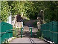
Two Footbridges
New footbridge's descending ramp crossing over railway, and old Victorian bridge, now a footbridge over canal.
Image: © Rob Emms
Taken: 19 Sep 2017
0.15 miles
9
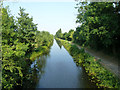
Slough arm of Grand Union Canal
Looking across the canal from the towpath on the southern bank. Behind the camera are business units on Waterside Drive.
Image: © Derek Harper
Taken: 20 Sep 2010
0.16 miles
10
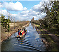
"Limehouse" Going Home
After working on garbage clearance at the top end of the Slough Arm, British Waterways boat Limehouse returns back down the canal.
Image: © Des Blenkinsopp
Taken: 14 Mar 2013
0.16 miles