IMAGES TAKEN NEAR TO
Cromwells Court, SLOUGH, SL3 6QH
Introduction
This page details the photographs taken nearby to Cromwells Court, SL3 6QH by members of the Geograph project.
The Geograph project started in 2005 with the aim of publishing, organising and preserving representative images for every square kilometre of Great Britain, Ireland and the Isle of Man.

There are currently over 7.5m images from over14,400 individuals and you can help contribute to the project by visiting https://www.geograph.org.uk
Image Map
Images are licensed for reuse under creativecommons.org/licenses/by-sa/2.0
Notes
- Clicking on the map will re-center to the selected point.
- The higher the marker number, the further away the image location is from the centre of the postcode.
Image Listing (4 Images Found)
Images are licensed for reuse under creativecommons.org/licenses/by-sa/2.0
Image
Details
Distance
1
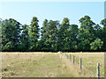
North of Marish Wharf
As often happens on the fringes of urban areas, along the north side of the Slough Canal is a fair sized tract of open land not used for anything much.
Image: © Des Blenkinsopp
Taken: 14 Mar 2013
0.15 miles
2
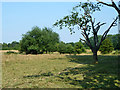
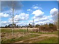
Bushy pasture, Langley
This appears to be, at least formerly, part of the estate farmland surrounding Langley Park. It was grazed by cattle.
Image: © Robin Webster
Taken: 21 Jul 2013
0.15 miles
3
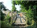
Footbridge near Trenches Farm
A public footpath crosses a stream and passes through a mobile homes park on the other side.
Image: © Robin Webster
Taken: 21 Jul 2013
0.16 miles