IMAGES TAKEN NEAR TO
Blenheim Close, Orchards Residential Park, SLOUGH, SL3 6QE
Introduction
This page details the photographs taken nearby to Blenheim Close, Orchards Residential Park, SL3 6QE by members of the Geograph project.
The Geograph project started in 2005 with the aim of publishing, organising and preserving representative images for every square kilometre of Great Britain, Ireland and the Isle of Man.

There are currently over 7.5m images from over14,400 individuals and you can help contribute to the project by visiting https://www.geograph.org.uk
Image Map
Images are licensed for reuse under creativecommons.org/licenses/by-sa/2.0
Notes
- Clicking on the map will re-center to the selected point.
- The higher the marker number, the further away the image location is from the centre of the postcode.
Image Listing (16 Images Found)
Images are licensed for reuse under creativecommons.org/licenses/by-sa/2.0
Image
Details
Distance
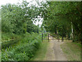
1
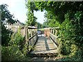
Footbridge near Trenches Farm
A public footpath crosses a stream and passes through a mobile homes park on the other side.
Image: © Robin Webster
Taken: 21 Jul 2013
0.05 miles
2
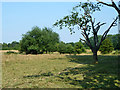
Bushy pasture, Langley
This appears to be, at least formerly, part of the estate farmland surrounding Langley Park. It was grazed by cattle.
Image: © Robin Webster
Taken: 21 Jul 2013
0.09 miles
3
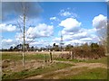
North of Marish Wharf
As often happens on the fringes of urban areas, along the north side of the Slough Canal is a fair sized tract of open land not used for anything much.
Image: © Des Blenkinsopp
Taken: 14 Mar 2013
0.14 miles
4
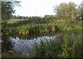
Slough arm of Grand Union Canal
Looking across the canal from the towpath on the southern bank. Behind the camera are business units on Waterside Drive.
Image: © Derek Harper
Taken: 20 Sep 2010
0.20 miles
5
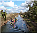
"Limehouse" Going Home
After working on garbage clearance at the top end of the Slough Arm, British Waterways boat Limehouse returns back down the canal.
Image: © Des Blenkinsopp
Taken: 14 Mar 2013
0.20 miles
6
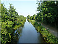
Slough Arm, Grand Union Canal
East of bridge 8.
Image: © Robin Webster
Taken: 21 Jul 2013
0.20 miles
7
Straight canal near Slough
The Slough arm of the Grand Union Canal looking east, the horizon pricked with power pylons.
Image: © Stephen Williams
Taken: 13 Jan 1991
0.20 miles
8
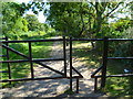
Towpath barrier, Slough Arm, Grand Union Canal
Preventing use by undesired modes of transport.
Image: © Robin Webster
Taken: 21 Jul 2013
0.21 miles
9
Orange Way after Wiltshire (478)
This fearsome structure has been designed to exclude motor traffic.
Image: © Shazz
Taken: 4 Sep 2013
0.22 miles
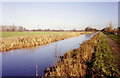
10
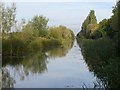
Slough arm of the Grand Union Canal
Looking away from Trenches Bridge; this is the start of a three kilometre straight stretch. Named footpath trails run on either side here; the Colne Valley Trail on the left, and the Grand Union Canal Walk on the right.
Image: © Derek Harper
Taken: 20 Sep 2010
0.22 miles