IMAGES TAKEN NEAR TO
Trenches Lane, SLOUGH, SL3 6DH
Introduction
This page details the photographs taken nearby to Trenches Lane, SL3 6DH by members of the Geograph project.
The Geograph project started in 2005 with the aim of publishing, organising and preserving representative images for every square kilometre of Great Britain, Ireland and the Isle of Man.

There are currently over 7.5m images from over14,400 individuals and you can help contribute to the project by visiting https://www.geograph.org.uk
Image Map
Images are licensed for reuse under creativecommons.org/licenses/by-sa/2.0
Notes
- Clicking on the map will re-center to the selected point.
- The higher the marker number, the further away the image location is from the centre of the postcode.
Image Listing (2 Images Found)
Images are licensed for reuse under creativecommons.org/licenses/by-sa/2.0
Image
Details
Distance
1

Iver Village Sign
B470 heading towards Iver.
Image: © Des Blenkinsopp
Taken: 5 Oct 2017
0.17 miles
2
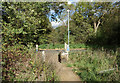
National Cycle Route 61
Leaving an off road section to join a country lane west of Iver.
Route 61 runs for 34 miles between Maidenhead and Rye House near Ware in Hertfordshire.
Image: © Des Blenkinsopp
Taken: 5 Oct 2017
0.21 miles