IMAGES TAKEN NEAR TO
Rudsworth Close, SLOUGH, SL3 0HR

Introduction

This page details the photographs taken nearby to Rudsworth Close, SL3 0HR by members of the Geograph project.

The Geograph project started in 2005 with the aim of publishing, organising and preserving representative images for every square kilometre of Great Britain, Ireland and the Isle of Man.

There are currently over 7.5m images from over14,400 individuals and you can help contribute to the project by visiting https://www.geograph.org.uk

Image Map


Images are licensed for reuse under creativecommons.org/licenses/by-sa/2.0
Notes
  • Clicking on the map will re-center to the selected point.
  • The higher the marker number, the further away the image location is from the centre of the postcode.

Image Listing (101 Images Found)

Images are licensed for reuse under creativecommons.org/licenses/by-sa/2.0
  • ...
Image
Details
Distance
1
The Colne Brook south of Park Street, Colnbrook
A "reverse" view is shown in Image (photographed by Robin Webster).
Image: © Mike Quinn Taken: 8 Aug 2018
0.01 miles
2
Bridge Street, Colnbrook
Image: © Ian S Taken: 15 Mar 2020
0.02 miles
3
Colnbrook Bridge and The Smithy
The Smithy building is boarded up. The bridge over the Colne Brook has some interesting features. On the parapets at the centre are stones giving the date, 1777, and the county boundary dividing line between 'Bucks' the near side, and 'Middx', the far side. However, the white plate informs us that in 1993 the bridge was strengthened and refurbished by Surrey County Council. Had they waited a bit, they could have saved some money, as in 1995 Colnbrook was transferred to Berkshire. Soon after, it became part of Slough Unitary Authority. There are not many places that have been in four counties or five county equivalents over the years.
Image: © Robin Webster Taken: 10 Jun 2017
0.02 miles
4
Colnbrook Bridge
The once important bridge carrying the old Bath road over the Colne Brook. Dated 1777 on the parapets, its strengthening and refurbishment in 1995 looks to have been a nearly complete rebuild, apart from parts of the parapets.
Image: © Robin Webster Taken: 10 Jun 2017
0.02 miles
5
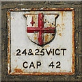
Coal tax boundary post no.77, Park Street, Colnbrook
The location of this post is shown in Image and Image - which also show the location of Image See also Image There were originally nearly 280 coal tax posts located around London, of which about 210 are still extant; around 180 of these (85%) are 3 ft high white-painted square bollards with a pyramidal top, decorative raised bands, and the shield from the City of London’s arms, like this one. Photos of the coal tax posts on Geograph are at http://www.geograph.org.uk/search.php?i=86542993&page=1 . The posts were erected under the Coal and Wine Duties (Continuation) Act of 1861 to mark the points at which duty had to be paid on coal being transported to London. The boundary was set at that of the Metropolitan Police District, and the resulting revenue was used by the Corporation of the City of London to fund public works. For further info see http://www.coaldutyposts.org.uk/cityposts.html .
Image: © Mike Quinn Taken: 8 Aug 2018
0.02 miles
6
Coal tax boundary marker no.78, Park Street, Colnbrook
The location of this boundary marker is shown in Image and Image There were originally nearly 280 coal tax posts located around London, of which about 210 are still extant; around 180 of these (85%) are 3 ft high white-painted square bollards with a pyramidal top, decorative raised bands, and the shield from the City of London’s arms. Photos of the coal tax posts on Geograph are at http://www.geograph.org.uk/search.php?i=86542993&page=1 . There are just 4 extant markers in situ of the type shown in the photo; the other three are Image, Image and Image The only other example is in a museum. The posts were erected under the Coal and Wine Duties (Continuation) Act of 1861 to mark the points at which duty had to be paid on coal being transported to London. The boundary was set at that of the Metropolitan Police District, and the resulting revenue was used by the Corporation of the City of London to fund public works. For further info see http://www.coaldutyposts.org.uk/cityposts.html .
Image: © Mike Quinn Taken: 8 Aug 2018
0.03 miles
7
Bridge over the Colne Brook, Park Street, Colnbrook
Shows the location of Image and Image The (north) parapet of the bridge also has a date stone with the date 1777 - see Image (photographed by Roger W Haworth). A view of the river and the south parapet is shown in Image (photographed by Robin Webster).
Image: © Mike Quinn Taken: 8 Aug 2018
0.03 miles
8
Colnbrook Bridge
See http://www.geograph.org.uk/photo/88250 and http://www.geograph.org.uk/photo/88255 for details about this bridge.
Image: © Ray Stanton Taken: 2 Mar 2006
0.03 miles
9
Coal tax boundary post no.77, Park Street, Colnbrook (detail)
See Image and Image
Image: © Mike Quinn Taken: 8 Aug 2018
0.03 miles
10
Park Street, Colnbrook (3)
Shows the location of Image and Image
Image: © Mike Quinn Taken: 8 Aug 2018
0.03 miles
  • ...