IMAGES TAKEN NEAR TO
Cumberland Avenue, SLOUGH, SL2 1AW
Introduction
This page details the photographs taken nearby to Cumberland Avenue, SL2 1AW by members of the Geograph project.
The Geograph project started in 2005 with the aim of publishing, organising and preserving representative images for every square kilometre of Great Britain, Ireland and the Isle of Man.

There are currently over 7.5m images from over14,400 individuals and you can help contribute to the project by visiting https://www.geograph.org.uk
Image Map
Images are licensed for reuse under creativecommons.org/licenses/by-sa/2.0
Notes
- Clicking on the map will re-center to the selected point.
- The higher the marker number, the further away the image location is from the centre of the postcode.
Image Listing (27 Images Found)
Images are licensed for reuse under creativecommons.org/licenses/by-sa/2.0
Image
Details
Distance
5
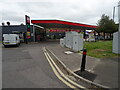
Service station off Cumberland Avenue, Slough
Petrol 175.9p.
Diesel 181.9p.
Image: © JThomas
Taken: 26 May 2022
0.14 miles
7
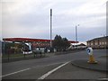
Texaco garage on Cumberland Avenue, Manor Park
Image: © David Howard
Taken: 9 Dec 2017
0.15 miles
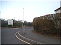
8
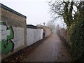
Path, Manor Park
Further north along the path shown in Image, here running between Canterbury Avenue and Hatton Avenue.
Image: © Derek Harper
Taken: 19 Nov 2010
0.15 miles

10
Penn Road, Manor Park
Penn Wood School is on the right
Image: © David Howard
Taken: 9 Dec 2017
0.16 miles