IMAGES TAKEN NEAR TO
Sherman Road, SLOUGH, SL1 3NE
Introduction
This page details the photographs taken nearby to Sherman Road, SL1 3NE by members of the Geograph project.
The Geograph project started in 2005 with the aim of publishing, organising and preserving representative images for every square kilometre of Great Britain, Ireland and the Isle of Man.

There are currently over 7.5m images from over14,400 individuals and you can help contribute to the project by visiting https://www.geograph.org.uk
Image Map
Images are licensed for reuse under creativecommons.org/licenses/by-sa/2.0
Notes
- Clicking on the map will re-center to the selected point.
- The higher the marker number, the further away the image location is from the centre of the postcode.
Image Listing (6 Images Found)
Images are licensed for reuse under creativecommons.org/licenses/by-sa/2.0
Image
Details
Distance
2
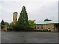
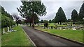
Path, Slough Crematorium
The main building is just through the shrubbery to the right.
Image: © Robin Webster
Taken: 13 Sep 2014
0.17 miles
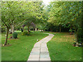
4
Muddy Lane (track)
That's the name on the map for this short bridleway. I've seen a lot muddier.
Image: © Des Blenkinsopp
Taken: 2 Nov 2018
0.21 miles
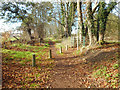
6
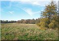
The Lanes Golf Course (disused)
This is quite unusual. I don't recall walking through a derelict golf course before. I thought there was an endless demand for them.
The Lanes course has obviously not been used for some time and is going back to rough grassland.
Image: © Des Blenkinsopp
Taken: 2 Nov 2018
0.24 miles